Filter: Categories of Wisconsin Historical Images
Filter: Subject of Harbors
Filter: Subject of cities and towns
Filter: Subject of dwellings
Filter: Categories of Wisconsin Historical Images
Filter: Subject of Harbors
Filter: Subject of cities and towns
Filter: Subject of dwellings

| Date: | 1886 |
|---|---|
| Description: | Bird's-eye view of Ashland, on the shores of Lake Superior, with insets of The Apostle Islands Chequamagon Bay & Ashland, and Distances from Ashland. |
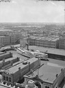
| Date: | |
|---|---|
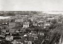
| Description: | Elevated view of Milwaukee, looking southwest from Mitchell block showing buildings, and the paddle steamer John A. Dix. |

| Date: | 1870 |
|---|---|
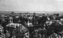
| Description: | Bird's-eye view of the city of Manitowoc with a population of 5,168 inhabitants as it appears in 1870, the year the village was granted a city charter by t... |

| Date: | 1857 |
|---|---|
| Description: | From Judge Smith Addition, 5th Ward, looking north, toward the city. Drawing is an elevated view of field and plank fence in foreground, road to the left a... |

| Date: | 1892 |
|---|---|
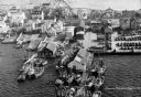
| Description: | Bird's-eye view of Chicago, with ships in the Lake Michigan harbor. |
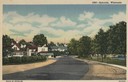
| Date: | 1951 |
|---|---|
| Description: | View down road curving towards Ephraim. Trees are along a lawn on the right near water. Caption reads: "Ephraim, Wisconsin". |

| Date: | 1915 |
|---|---|
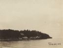
| Description: | View from hill across Eagle Bay with buildings and trees in the foreground. Caption reads: "Across Eagle Bay, Ephraim, Wis." |
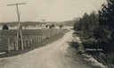
| Date: | 1905 |
|---|---|
| Description: | A lane in Ephraim with power lines lining the road. There is a body of water in the distance with houses on the far shoreline. |
| Date: | 1889 |
|---|---|
| Description: | Elevated view looking north toward the harbor with multiple buildings in the foreground. |
| Date: | 1900 |
|---|---|
| Description: | View across water of a dock and buildings on Lake Michigan. |

| Date: | 1940 |
|---|---|
| Description: | Basin or slip area. City buildings can be seen on a hill in the background. Various boats are in the river and on the shoreline. A path with stairs lead... |

| Date: | 1940 |
|---|---|
| Description: | Basin or slip area. The city is on a hill in the background, and boats are in the river. On the left is a sidewalk and railing with stairs. People are wa... |

| Date: | |
|---|---|
| Description: | Elevated view of Fort Seward from Mount Rippinsky, showing Pyramid Harbor and Davidson Glacier in distance. Caption reads: "Haines and Fort Wm. H. Seward f... |
| Date: | |
|---|---|
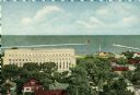
| Description: | Aerial view of a harbor with a wharf in the foreground, and buildings and boathouses along the shoreline. |

| Date: | |
|---|---|
| Description: | Elevated view of village homes on the shores of the bay with docked fishing boats in the foreground. Caption reads, "Marblehead, Mass from Rockmere Point." |
| Date: | |
|---|---|
| Description: | Elevated view looking down on the town with the bay and opposite shoreline in distance. |
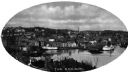
| Date: | |
|---|---|
| Description: | Elevated view of Norwich harbor. Oval-framed view features two ships in the river harbor as well as buildings on the waterfront and on the surrounding hill... |
If you didn't find the material you searched for, our Library Reference Staff can help.
Call our reference desk at 608-264-6535 or email us at: