 Filter: Categories of Wisconsin Historical Images
Filter: Subject of Harbors
Filter: Subject of bridges
Filter: Categories of Wisconsin Historical Images
Filter: Subject of Harbors
Filter: Subject of bridges
| Date: | |
|---|---|
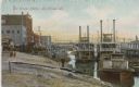
| Description: | Harbor full of steamboats. The shoreline is bustling with people walking amidst the buildings, piers and bridges. Caption reads: "La Crosse Harbor, La Cros... |

| Date: | 1907 |
|---|---|
| Description: | Text on front reads: "Racine, Wis. in 1850." Artist's rendering of the view of the harbor with sailing ships, sailboats, rowboats and canoes. The Main Stre... |
| Date: | |
|---|---|
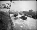
| Description: | Elevated view of tugboat pulling a steamer caked in ice in a canal. Steam is rising from the water and an open drawbridge can be seen in the background. On... |
| Date: | |
|---|---|
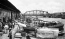
| Description: | A view of small boats docked at a waterfront market in Tampico, Mexico showing a crowd of men in front of a waterfront warehouse, a steel bridge in the bac... |
| Date: | |
|---|---|
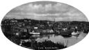
| Description: | Elevated view of Norwich harbor. Oval-framed view features two ships in the river harbor as well as buildings on the waterfront and on the surrounding hill... |

| Date: | 1939 |
|---|---|
| Description: | Elevated view of harbor, boats, and factories. |

| Date: | 1900 |
|---|---|
| Description: | View of a harbor featuring waterfront businesses, piers, and moored boats. The harbor is found on the Chicago, Milwaukee & Puget Sound Railway line, which... |

| Date: | 1941 |
|---|---|
| Description: | Elevated view of Sturgeon Bay in 1900. Sturgeon Bay Bridge spans the bay and several boats are on the water. A lighthouse sits on a small island in the bay... |

| Date: | 1855 |
|---|---|
| Description: | This map has relief shown by hachures and soundings and shows local streets, proposed roads, railroads, bridge wharfs, basin, north arm, and west arm of Ke... |
| Date: | 2012 |
|---|---|
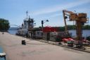
| Description: | United States Coast Guard boat and a dredging barge at the Riverside Park, Levee Dock, a United States port facility on the Mississippi River. A brick walk... |
| Date: | |
|---|---|
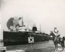
| Description: | Composite photograph in the "Tall Tale" style. An enormous bovine stands on the front deck of the Pere Marquette 21, a steamer. On the right, on the... |

| Date: | |
|---|---|
| Description: | Aerial view of harbors and bridge. Farm fields are on either side of the bridge. The city of Sturgeon Bay is in the distance. There are docks along the sho... |

| Date: | |
|---|---|
| Description: | Aerial view of harbor. In the foreground is a lighthouse and breakwaters. Bridges cross the harbor, and there are factory and industrial buildings near the... |

| Date: | |
|---|---|
| Description: | Aerial view of Marinette Harbor looking out towards Lake Superior. A lighthouse and breakwater extend out into the lake. Industrial buildings, cranes, and ... |

| Date: | 1907 |
|---|---|
| Description: | This map is a chart of Milwaukee Harbor that displays local streets, bridges, roads, railroads, public buildings, businesses, factories, dry docks, parks, ... |

| Date: | 07 19 1854 |
|---|---|
| Description: | This hand-colored map shows the North and South Pier, the North Pier Bridge, the present Channel, and the Channel to be dredged. Lake Michigan and a light ... |

| Date: | |
|---|---|
| Description: | TD-14 in New Zealand bridge construction. Original caption reads: "The Bailey bridge provided access to the incompleted portion of the bank and was built o... |
| Date: | 1875 |
|---|---|
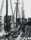
| Description: | Elevated view of a deck of a schooner hauling lumber. Several workmen are loading or unloading the lumber. Industrial buildings, some displaying signs, are... |

| Date: | 11 1781 |
|---|---|
| Description: | Map of New York, Staten Island, and Long Island, showing the placements of forts, and the movement of troops in 1776. The map also includes towns, cities, ... |
| Date: | |
|---|---|
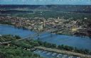
| Description: | Photographic postcard of an aerial view over La Crosse and the I-90 Interstate bridge. French Island is in the foreground. |
If you didn't find the material you searched for, our Library Reference Staff can help.
Call our reference desk at 608-264-6535 or email us at: