 Filter: Categories of Wisconsin Historical Images
Filter: Subject of Harbors
Filter: Subject of bathing beaches
Filter: Categories of Wisconsin Historical Images
Filter: Subject of Harbors
Filter: Subject of bathing beaches

| Date: | 1968 |
|---|---|
| Description: | A man walking with a cane in the sand dunes on Coney Island. A dilapidated fence cuts across the foreground of the beach and a rock jetty juts into the ba... |

| Date: | |
|---|---|
| Description: | Elevated view down Beach Boulevard, a boardwalk-like street with gift shops and carnival events facing the beach and harbor. Crowds of people are on the si... |

| Date: | 1938 |
|---|---|
| Description: | This map shows roads, parks, golf courses, airports, beaches, docks and harbors, lighthouses, and buoys within Winnebago County and parts of Waushara, Calu... |

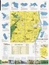
| Date: | 1970 |
|---|---|
| Description: | This map shows roads, parks, swimming beaches, golf courses, yacht harbors, light houses, airports, public hunting grounds, waysides, schools, and fishing ... |
| Date: | 1970 |
|---|---|
| Description: | This map includes illustrations, a location map, text, lakes fishing guide, beaches, harbor and yacht clubs, and bathymetric maps of 10 lakes: Beechwood La... |
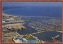
| Date: | 1975 |
|---|---|
| Description: | Text on reverse: "Magnificent view of Lake Michigan shoreline from Racine Harbor to Wind Point Lighthouse. Photo Courtesy RAMAC." Aerial view of Racine Har... |
If you didn't find the material you searched for, our Library Reference Staff can help.
Call our reference desk at 608-264-6535 or email us at: