 Filter: Categories of Wisconsin Historical Images
Filter: Subject of Harbors
Filter: County of Door
Filter: Categories of Wisconsin Historical Images
Filter: Subject of Harbors
Filter: County of Door
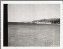
| Date: | 1915 |
|---|---|
| Description: | View from shoreline over water towards the Coast Guard Station and houses at Baileys Harbor. The long pier extending from the station's boathouse is easily... |
| Date: | 1924 |
|---|---|
| Description: | Elevated view of the photographer's son, Ferdinand Leonard (Fedy) sitting on the bluff overlooking Fish Creek Harbor. The old warehouses are seen on the pi... |
| Date: | 1920 |
|---|---|
| Description: | View from the water of Washington Harbor on Washington Island. There are boats moored and warehouses along the pier. Fishing nets dry on racks on the shore... |

| Date: | 1916 |
|---|---|
| Description: | This Wisconsin Conservation Commission map from 1916 shows Peninsula State Park in the Town of Gibraltar, Door County, Wisconsin. Depicted are open and pla... |

| Date: | 1916 |
|---|---|
| Description: | This version of a 1916 Wisconsin Conservation Commission map shows Peninsula State Park in the Town of Gibraltar, Door County, Wisconsin. Depicted are open... |
| Date: | 1915 |
|---|---|
| Description: | Winter scene from Egg Harbor Road (Highway 42) in Fish Creek looking north toward frozen Fish Creek Harbor with the bluffs in Peninsula State Park beyond. ... |

| Date: | 1913 |
|---|---|
| Description: | Two of the photographer's children, Margaret (Sissy), left, and Ferdinand Leonard (Fedy), right, on Weborg Point. Fish Creek Harbor is in the background; t... |

| Date: | 1915 |
|---|---|
| Description: | Elevated view over a heavily wooded area to Fish Creek Harbor and Hen Island, with Peninsula State Park in the background. |
| Date: | 1915 |
|---|---|
| Description: | View from shoreline over water towards a three-masted sailing vessel docked at Baileys Harbor pier. Houses and commercial buildings line the shore. |
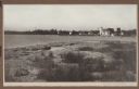
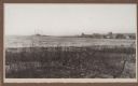
| Date: | 1910 |
|---|---|
| Description: | Photographic postcard view across rocky field of dwellings and other buildings along Lake Michigan. Along the left is a rocky ledge. The shoreline of the h... |

| Date: | 1972 |
|---|---|
| Description: | Aerial view of commercial buildings and dwellings along the shore of Lake Michigan. Caption reads: "Baileys Harbor, Wisc." |

| Date: | 1941 |
|---|---|
| Description: | Elevated view of Sturgeon Bay in 1900. Sturgeon Bay Bridge spans the bay and several boats are on the water. A lighthouse sits on a small island in the bay... |
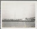
| Date: | 1958 |
|---|---|
| Description: | View from pier of Peterson's Boat Works in Sturgeon Bay. |

| Date: | 06 25 1901 |
|---|---|
| Description: | This map shows beacons, buoys, docks, quarries, streets, and buildings. The map inset shows the Harbor of refuge at entrance to Sturgeon Bay and Lake Michi... |
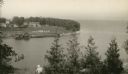
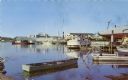
| Date: | 07 25 1960 |
|---|---|
| Description: | Ephraim pier in Eagle Harbor. The pier is made of timbers. A dock and boathouse are on the right. Bare masts rise above the boats. The shoreline and trees ... |
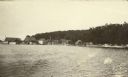
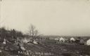
| Date: | 04 17 1963 |
|---|---|
| Description: | Egg Harbor pier. The shoreline and trees are on the right. There is a cottage area along the shoreline along with a small beach. |

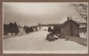
| Date: | 01 06 1958 |
|---|---|
| Description: | Ahnapee & Western Railway Bridge from north side of frozen Sturgeon Bay. The bridge is made of wood (and steel supports???). There is a dock in the foregro... |

| Date: | 01 06 1958 |
|---|---|
| Description: | View of the Ship Canal from the Coast Guard station. There are pieces of machinery on the right, and a line of trees on the left. There is snow on the grou... |

| Date: | |
|---|---|
| Description: | Aerial view of harbors and bridge. Farm fields are on either side of the bridge. The city of Sturgeon Bay is in the distance. There are docks along the sho... |

| Date: | 04 1926 |
|---|---|
| Description: | This blueprint mostly shows various numbers within the canal and bay. Lake Michigan and Harobor of Refuge are shown along the far right side. Near the harb... |
If you didn't find the material you searched for, our Library Reference Staff can help.
Call our reference desk at 608-264-6535 or email us at: