 Filter: Categories of Wisconsin Historical Images
Filter: Subject of Harbors
Filter: Creator Name of Unknown
Filter: Categories of Wisconsin Historical Images
Filter: Subject of Harbors
Filter: Creator Name of Unknown

| Date: | 1865 |
|---|---|
| Description: | This map shows the river shore and piers. Lake Michigan is labeled. Depths are shown by soundings and isolines. The bottom margin includes notes on soundi... |

| Date: | 1874 |
|---|---|
| Description: | This map shows piers, streets, the Manitowoc River and shore lines of 1856, 1869, 1873 and 1874. The top margin reads; "Soundings taken 1974." Written in i... |

| Date: | 10 13 1864 |
|---|---|
| Description: | This map shows the shore line of Oct. 14 1864, city limits of water lots, and the elevation of water in Lake Michigan. Depths are shown by soundings. |

| Date: | 10 1853 |
|---|---|
| Description: | This map shows warehouses and proposed extensions of piers. "Note: The soundings are in feet and tenths." The upper left margin reads: "Senate Ex. Doc. No.... |

| Date: | 10 1853 |
|---|---|
| Description: | This map shows warehouses and proposed extensions of piers. Also included are notes on soundings and the proposed extensions. The upper right margin reads:... |

| Date: | 1865 |
|---|---|
| Description: | This map shows a proposed extension and the shore line of Sept. ’65. Lake Michigan is labeled. Depths are shown by soundings. |

| Date: | 1865 |
|---|---|
| Description: | This map shows the harbor with proposed extensions and the shore line as it appeared in 1865. Depths are shown by soundings. |

| Date: | 1857 |
|---|---|
| Description: | This map shows piers, wharves, streets, and the lake shore from the survey of August 1856. Lake Michigan and the Sheboygan River are labeled. Depths are sh... |

| Date: | 1905 |
|---|---|
| Description: | This map shows railroads, towns, lights, lights to be established, fog signals, light-vessels, lighted buoys, light-house depots, and light-house reservati... |
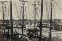
| Date: | |
|---|---|
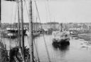
| Description: | Elevated view of commercial boats in Manitowoc Harbor. |

| Date: | 1970 |
|---|---|
| Description: | This map shows roads, parks, swimming beaches, golf courses, yacht harbors, light houses, airports, public hunting grounds, waysides, schools, and fishing ... |

| Date: | 1936 |
|---|---|
| Description: | This map shows campsites, trails, auto roads, surrounding townships, and points of interest, by including pictorial illustrations. Includes an inserted map... |
| Date: | 1902 |
|---|---|
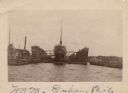
| Description: | View across water towards a ship docked in a floating harbor at Sturgeon Bay. There is a shoreline in the background. |

| Date: | |
|---|---|
| Description: | Two ships docked in a Door County harbor, possibly at Sturgeon Bay. The ship at left is the Oak Leaf. The ship at right is the L.N. Foster ow... |

| Date: | |
|---|---|
| Description: | View across water towards the lumber steamer Chas. B. Packard docked with a load of lumber. Several crew members are standing on the deck, and men a... |
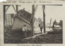
| Date: | 11 29 1908 |
|---|---|
| Description: | Men working on pulling the boat "Fish Hawk" out of the water. One man is kneeling in front of the boat and looking at the camera. A man in the background i... |

| Date: | |
|---|---|
| Description: | View across water towards the "Carolina" steamer docked at Ephraim. Many people are standing on the pier. Caption reads: "Ephraim-Wis." |
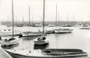
| Date: | |
|---|---|
| Description: | View of the marina, with several docked sailboats. The tree-lined shoreline is in the background. Caption reads: "Busy Pier Scene, Fish Creek, Wis." |

| Date: | 02 01 1919 |
|---|---|
| Description: | View from ship as a crowd on a pier is saying goodbye to "Espagne" as it is sailing away. Captioned: "The crowd at the pier as the 'Espagne' left for Borde... |
| Date: | 1887 |
|---|---|
| Description: | Caption reads: "Some of the Old-Timers on the Photo. Steamers: Petosky (on stocks), Muskegon, Corona, A.D. Hayward, City of St. Joe, Lotus, J.F. Dayan, Gra... |
If you didn't find the material you searched for, our Library Reference Staff can help.
Call our reference desk at 608-264-6535 or email us at: