 Filter: Categories of Wisconsin Historical Images
Filter: Subject of Harbors
Filter: Creator Name of Unknown
Filter: Categories of Wisconsin Historical Images
Filter: Subject of Harbors
Filter: Creator Name of Unknown

| Date: | |
|---|---|
| Description: | View of expansive gardens rolling down to a harbor. |

| Date: | 1857 |
|---|---|
| Description: | This map of Sheboygan Harbor shows the river mouth and harbor, piers, wharfs, piles of old destroyed bridge wharfs, streets, and the lake shore from survey... |

| Date: | 05 1958 |
|---|---|
| Description: | Photocopy of a map created by the City of Milwaukee Master Plan Program City Planning Division in May of 1958 representing 1870 "THE CENTRAL AREA OF THE CI... |

| Date: | 1836 |
|---|---|
| Description: | This map is pen-and-ink on paper and shows marshlands, rivers, creeks, a quarry, and a few roads. |
| Date: | 1918 |
|---|---|
| Description: | View of Solombola from Archangel [Archangelsk], Russia. In the distance are series of cranes. In the foreground on the ice are stacks of logs near a pier m... |
| Date: | 1918 |
|---|---|
| Description: | View over pier made of pilings towards a floating drydock, now embedded in the ice, near Solombola, Russia. There are tall buildings behind it on the oppos... |

| Date: | 1918 |
|---|---|
| Description: | Elevated view looking down gutter of roof towards the British volunteer forces parading in Archangel [Archangelsk], Russia right before they disembarked fr... |

| Date: | 1918 |
|---|---|
| Description: | Elevated view from roof of British volunteer forces parading in Archangel [Archangelsk], Russia right before they disembarked from the town. The crowd watc... |
| Date: | 1910 |
|---|---|
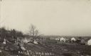
| Description: | Photographic postcard view across rocky field of dwellings and other buildings along Lake Michigan. Along the left is a rocky ledge. The shoreline of the h... |

| Date: | 1909 |
|---|---|
| Description: | This map of Duluth and Superior was issued by the Duluth Street Railway Company and shows street railway routes in the cities, as well as lakes, bays, harb... |

| Date: | 1964 |
|---|---|
| Description: | This map of Two Rivers shows the Rodgers street fishing area and land use. The map features a legend on the right of the types of land use. The map also sh... |

| Date: | |
|---|---|
| Description: | Exterior of the menu for Paul's Cafe, with a bird's-eye view map of "Washburn's Natural Deep Water Land Locked Harbor," Chequamegon Bay, and the Apostle Is... |

| Date: | 1910 |
|---|---|
| Description: | In her journal from China, Carrie describes a scene from the harbor: "There are a multitude of boats. The sails are colored like birch. The water under a c... |

| Date: | 1900 |
|---|---|
| Description: | This map shows streets, railroads, dock and harbor lines, and parks. The map includes population tables for 1880, 1890, 1900. |

| Date: | 01 06 1958 |
|---|---|
| Description: | Ahnapee & Western Railway Bridge from north side of frozen Sturgeon Bay. The bridge is made of wood (and steel supports???). There is a dock in the foregro... |

| Date: | 01 06 1958 |
|---|---|
| Description: | View of the Ship Canal from the Coast Guard station. There are pieces of machinery on the right, and a line of trees on the left. There is snow on the grou... |

| Date: | 01 08 1958 |
|---|---|
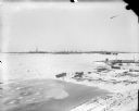
| Description: | Elevated view from 8th Street Bridge over the Manitowoc River towards Lake Michigan. There is a lighthouse in the distance. Ice is floating on the water. A... |

| Date: | 01 08 1958 |
|---|---|
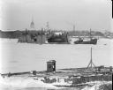
| Description: | Elevated view over icy water towards ships in the shipyard on the left, and the cement company in the background. Cranes and industrial buildings are in th... |

| Date: | 01 07 1958 |
|---|---|
| Description: | View from the Second Street bridge over the icy Ahnapee River towards Lake Michigan. A lighthouse is at the end of a jetty in the far background. Boats are... |
| Date: | 01 07 1958 |
|---|---|
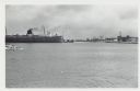
| Description: | View across water to ship moored at a dock. Smoke is coming out of the smokestack. Industrial buildings are across the water on the right. |
If you didn't find the material you searched for, our Library Reference Staff can help.
Call our reference desk at 608-264-6535 or email us at: