 Filter: Categories of Wisconsin Historical Images
Filter: Subject of Harbors
Filter: Creator Name of Unknown
Filter: Subject of islands
Filter: Categories of Wisconsin Historical Images
Filter: Subject of Harbors
Filter: Creator Name of Unknown
Filter: Subject of islands
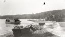
| Date: | 1929 |
|---|---|
| Description: | One of the four harbors on Washington Island. There is a man on a pier or dock in the foreground, and a boat approaching on the left. A tree-lined shorelin... |
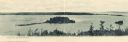
| Date: | 1910 |
|---|---|
| Description: | View of Sawyer Harbor as seen from Government Bluff. |

| Date: | 1950 |
|---|---|
| Description: | Harbor area of Jones Island and garbage disposal plant, Stratton Grain Co., and more. |
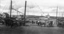
| Date: | |
|---|---|
| Description: | A view toward a wharf with horse-drawn vehicles in the foreground, and a steamship in the distance. |

| Date: | |
|---|---|
| Description: | Hand-drawn map of the area at the time of Pilgrim landing, drawn by Charles Blaskowikz. Includes commemorative historical notes. |

| Date: | |
|---|---|
| Description: | Elevated view of Wickets Island, a small island in a bay with dense foliage. A large tower is on the island and boats are in the bay. |

| Date: | |
|---|---|
| Description: | Bird's-eye view lithograph of Key West with ships and smaller boats in the surrounding waters. |
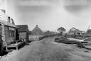
| Date: | |
|---|---|
| Description: | General view of town streets, with a harbor and early American store exteriors. |

| Date: | |
|---|---|
| Description: | Distant view of the city from the mountains, looking out over the bay. Mountains can be seen across the water. Copyright by Winter & Pond. |

| Date: | |
|---|---|
| Description: | Ruins of a Mormon cabin built of squared logs. A harbor is visible in the background. |

| Date: | 1936 |
|---|---|
| Description: | This map shows campsites, trails, auto roads, surrounding townships, and points of interest, by including pictorial illustrations. Includes an inserted map... |

| Date: | 1853 |
|---|---|
| Description: | A map of Wellfleet Harbor on Cape Cod Bay. |

| Date: | 1814 |
|---|---|
| Description: | A map of the Harbour (sic) of St. Catherine (Brazil). |
If you didn't find the material you searched for, our Library Reference Staff can help.
Call our reference desk at 608-264-6535 or email us at: