Filter: Categories of Wisconsin Historical Images
Filter: Subject of Harbors
Filter: Creator Name of Unknown
Filter: County of Sheboygan
Filter: Categories of Wisconsin Historical Images
Filter: Subject of Harbors
Filter: Creator Name of Unknown
Filter: County of Sheboygan

| Date: | 1857 |
|---|---|
| Description: | This map of Sheboygan Harbor shows the river mouth and harbor, piers, wharfs, piles of old destroyed bridge wharfs, streets, and the lake shore from survey... |

| Date: | 1865 |
|---|---|
| Description: | This map shows the harbor with proposed extensions and the shore line as it appeared in 1865. Depths are shown by soundings. |

| Date: | 1857 |
|---|---|
| Description: | This map shows piers, wharves, streets, and the lake shore from the survey of August 1856. Lake Michigan and the Sheboygan River are labeled. Depths are sh... |
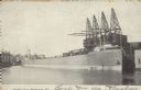
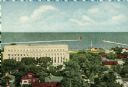
| Date: | 10 17 1906 |
|---|---|
| Description: | Text on front reads: "Harbor View - Sheboygan, Wis." A lake freighter, or "laker" is docked at the harbor. |
If you didn't find the material you searched for, our Library Reference Staff can help.
Call our reference desk at 608-264-6535 or email us at: