 Filter: Categories of Wisconsin Historical Images
Filter: Subject of Harbors
Filter: Creator Name of Unknown
Filter: Community of Milwaukee
Filter: Categories of Wisconsin Historical Images
Filter: Subject of Harbors
Filter: Creator Name of Unknown
Filter: Community of Milwaukee
| Date: | |
|---|---|
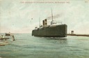
| Description: | The screw rail ferry, Pere Marquette 18, entering the harbor. Caption reads: "Pere Marquette Steamer Entering, Milwaukee, Wis." |
| Date: | |
|---|---|
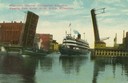
| Description: | Colorized view depicting the passenger excursion vessel, "Christopher Columbus," approaching the East Water Street Bridge. Caption reads: "Whaleback Steame... |

| Date: | 1862 |
|---|---|
| Description: | Drawn the second year of the Civil War, this 1862 map of Milwaukee shows post offices, light houses, beacon lights, county buildings, elevator warehouses, ... |

| Date: | 04 01 1975 |
|---|---|
| Description: | The bridge over the Milwaukee Harbor named in honor of former Mayor Daniel Hoan. The bridge was constructed between 1970 and 1972, but during the period de... |

| Date: | 1950 |
|---|---|
| Description: | Harbor area of Jones Island and garbage disposal plant, Stratton Grain Co., and more. |

| Date: | 1940 |
|---|---|
| Description: | Aerial view of city, river and harbor. Two smokestacks are on either side of the river mouth. |

| Date: | 1940 |
|---|---|
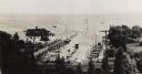
| Description: | Basin or slip area. City buildings can be seen on a hill in the background. Various boats are in the river and on the shoreline. A path with stairs lead... |

| Date: | 1940 |
|---|---|
| Description: | Basin or slip area. The city is on a hill in the background, and boats are in the river. On the left is a sidewalk and railing with stairs. People are wa... |
| Date: | 1940 |
|---|---|
| Description: | View from hill of the yacht club, with Lake Michigan behind. In the distance is the jetty, and the road along the shoreline is N. Lincoln Memorial Drive. T... |

| Date: | 1953 |
|---|---|
| Description: | Aerial view looking north from the foot of Milwaukee's main thoroughfare, Wisconsin Avenue. Lincoln Memorial Drive winds its way along the lagoon in Juneau... |

| Date: | 05 1958 |
|---|---|
| Description: | Photocopy of a map created by the City of Milwaukee Master Plan Program City Planning Division in May of 1958 representing 1870 "THE CENTRAL AREA OF THE CI... |

| Date: | 10 13 1864 |
|---|---|
| Description: | This map shows the shore line of Oct. 14 1864, city limits of water lots, and the elevation of water in Lake Michigan. Depths are shown by soundings. |
If you didn't find the material you searched for, our Library Reference Staff can help.
Call our reference desk at 608-264-6535 or email us at: