 Filter: Categories of Wisconsin Historical Images
Filter: Subject of Guard fences
Filter: Year of 1900-1999
Filter: Year of 1920-1929
Filter: Categories of Wisconsin Historical Images
Filter: Subject of Guard fences
Filter: Year of 1900-1999
Filter: Year of 1920-1929
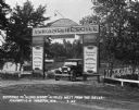
| Date: | 07 1927 |
|---|---|
| Description: | Car parked underneath the entrance gate to the Island Resort at the Wisconsin Dells, 25 miles from the Dells on Highway 12-16 near Mauston. Entrance gate a... |
| Date: | 01 09 1928 |
|---|---|
| Description: | Difference in paint on fences on a state highway. |
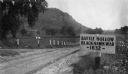
| Date: | 1927 |
|---|---|
| Description: | View of the Battle Hollow sign along an unpaved road. In the distance on the left is a rock formation covered with trees. Sign reads: "Battle Hollow Clack ... |
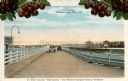
| Date: | 1920 |
|---|---|
| Description: | View of two automobiles crossing a toll bridge. There are cherries on branches at the top of the postcard. Caption reads: "In Door County 'Cherryland,' The... |
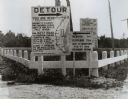
| Date: | 1920 |
|---|---|
| Description: | Detour sign posted by the Wisconsin Highway Commission, the predecessor of the Department of Transportation, in Manitowoc showing a confusing detour route ... |
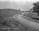
| Date: | 1920 |
|---|---|
| Description: | Loganville Road in Sauk County taken by the Wisconsin Good Roads Association. The photograph was meant to create a contrast between the new improved road ... |
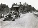
| Date: | 07 20 1929 |
|---|---|
| Description: | Emil Anderson operates a road grader marked "Russell Motor Patrol No.3" on Highway 12. |
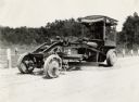
| Date: | 07 20 1927 |
|---|---|
| Description: | Emil Anderson operating a road grader marked "Russell Motor Patrol No.3" on Highway 12. |

| Date: | 12 1926 |
|---|---|
| Description: | Two men standing by a guard rail along the side of a road to look at a snow-covered automobile resting on its side. |
| Date: | 07 1927 |
|---|---|
| Description: | Automobiles approaching a turn in a paved road with billboards on either side. Photograph taken for International Harvester's Agricultural Extension Depart... |

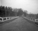
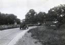
| Date: | 1925 |
|---|---|
| Description: | View down steep road with guard rail. A car is parked on the side of the road on the right. Over the railing, there is a river and a town with a church bui... |

| Date: | 03 25 1925 |
|---|---|
| Description: | Elevated view of a Model 63 International moving van owned by Frank Razey Moving Company driving down a rural highway. A barn is in the background. |

| Date: | 1925 |
|---|---|
| Description: | A view looking up a winding road with rows of utility lines on both sides. The road is partially fenced. |
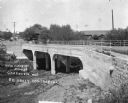
| Date: | 1921 |
|---|---|
| Description: | View from opposite bank of two horse-drawn buggies crossing the newly constructed bridge over a river. |

| Date: | 04 07 1924 |
|---|---|
| Description: | Exterior view of International Harvester's Philadelphia branch house. Automobiles are parked in a cul-de-sac in front of the building; a sign reading: "Int... |
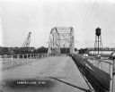
| Date: | 1927 |
|---|---|
| Description: | View down middle of metal bridge across the Cornell Flowage. Across the lake, there is the pulpwood stacker on the left and a water tower on the right near... |
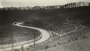
| Date: | 1920 |
|---|---|
| Description: | View from hillside of car driving down a winding road. Their are cornfields on both sides of the road. |
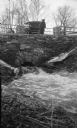
| Date: | 04 1922 |
|---|---|
| Description: | The photographer's wife Clothilde leans on a railing, looking at water rushing through a stone culvert on Fish Creek. Their car is parked on the roadway. A... |

| Date: | 1925 |
|---|---|
| Description: | View down the road leading to the PET evaporated milk factory. A painted sign on the factory's exterior wall claims PET evaporated milk is "milk at its bes... |
If you didn't find the material you searched for, our Library Reference Staff can help.
Call our reference desk at 608-264-6535 or email us at:
