 Filter: Categories of Wisconsin Historical Images
Filter: Subject of Guard fences
Filter: Subject of trees
Filter: Year of 1900-1999
Filter: Year of 1930-1939
Filter: Categories of Wisconsin Historical Images
Filter: Subject of Guard fences
Filter: Subject of trees
Filter: Year of 1900-1999
Filter: Year of 1930-1939
| Date: | 11 18 1930 |
|---|---|
| Description: | Trees cut down along US Hwy 12, South Beltline Highway, between John Nolen Drive & South Towne Drive. "Between the overhead grade crossing viaduct and the ... |
| Date: | 11 18 1930 |
|---|---|
| Description: | Trees cut down along US Hwy 12, South Beltline Highway, between John Nolen Drive & South Towne Drive. "Between the overhead grade crossing viaduct and the ... |
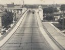
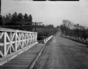
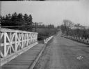
| Date: | 1935 |
|---|---|
| Description: | Elevated view of the bridge, with several cars driving on it. On the left and right are streets below the bridge. In the distance are smokestacks and water... |
| Date: | 1935 |
|---|---|
| Description: | View of Kohler Ravine Park. In the right foreground is a small bridge, and on the right is a set of wide, concrete steps leading from the road down the hil... |
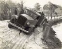
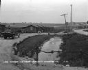
| Date: | 12 08 1936 |
|---|---|
| Description: | Men gather around an International D-40 truck stuck in soft sand on a road along a shoreline. |
| Date: | 1935 |
|---|---|
| Description: | View across road of an automobile parked next to a building that has a gasoline pump in front of it by the dirt road of County Trunk B. There is a hand-pai... |
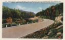
| Date: | 1933 |
|---|---|
| Description: | Colorized postcard of a paved road curving to the left through trees, shrubs and bluffs. A dirt road can be seen to the left, and the sky is blue with a fe... |
| Date: | 1936 |
|---|---|
| Description: | Guardrail along Highway 63, bordered with dense vegetation. |
| Date: | 1937 |
|---|---|
| Description: | Restaurant west of Iron River on Highway 2. This establishment was torn down around 2003 when the Wisconsin Department of Transportation widened the Highwa... |
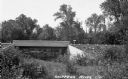
| Date: | 1935 |
|---|---|
| Description: | View from side of river of cement bridge over the Chippewa River in Sawyer County, possibly on County Highway B. |

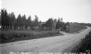
| Date: | 1932 |
|---|---|
| Description: | Looking west along County Trunk Highway SS (now CTH DD) from the hill east of the New Fane School. The brick school, with its bell tower and widow's walk, ... |
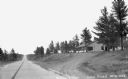
| Date: | 1930 |
|---|---|
| Description: | View from driveway over a stream towards a row of six log cabins to the left Highway 51. A Texaco Station and a delivery truck are on the far left. Cars ar... |

| Date: | 1935 |
|---|---|
| Description: | A narrow, unpaved road passes under a rustic log arbor-like gate which marks the entrance to Bradley Park. The area is heavily wooded with tall but immatur... |

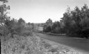
| Date: | 1937 |
|---|---|
| Description: | View of curve in unpaved road, with a guard rail on the right. There is erosion underneath trees just beyond the curve of the road. A road sign on the righ... |
If you didn't find the material you searched for, our Library Reference Staff can help.
Call our reference desk at 608-264-6535 or email us at:
