 Filter: Categories of Wisconsin Historical Images
Filter: Subject of Guard fences
Filter: Subject of trees
Filter: Creator Name of Unknown
Filter: Categories of Wisconsin Historical Images
Filter: Subject of Guard fences
Filter: Subject of trees
Filter: Creator Name of Unknown
| Date: | 1935 |
|---|---|
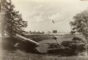
| Description: | View of Kohler Ravine Park. In the right foreground is a small bridge, and on the right is a set of wide, concrete steps leading from the road down the hil... |
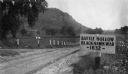
| Date: | 1927 |
|---|---|
| Description: | View of the Battle Hollow sign along an unpaved road. In the distance on the left is a rock formation covered with trees. Sign reads: "Battle Hollow Clack ... |

| Date: | |
|---|---|
| Description: | A dirt road along the shore, featuring a log guardrail and a boathouse in the distance. Caption reads: "The Shore Road, Lloyd's Neck, Huntington, N.Y." |

| Date: | |
|---|---|
| Description: | A view of a country dirt road with a car pulled over to the right side. The road is part of the Pennsylvania State Highway, and is bordered by a fence on o... |

| Date: | |
|---|---|
| Description: | Elevated view of the Lincoln Highway, also known as the Juniata Bridge, or Juniata Crossing. View toward right side of bridge over a river, with tree-cover... |

| Date: | 08 14 1929 |
|---|---|
| Description: | Text on front reads: "Lovers Lane, Sauk City, Wis." An unpaved, rural road with a wooden guard rail on both sides. A sign reads: "Automobiles Go Slow." Beh... |

| Date: | 1950 |
|---|---|
| Description: | Text on front reads: "Wisconsin River Bridge, Spring Green, Wis." A truss bridge with eight spans over the Wisconsin River on State Highway 14. The bridge ... |
If you didn't find the material you searched for, our Library Reference Staff can help.
Call our reference desk at 608-264-6535 or email us at: