Filter: Categories of Wisconsin Historical Images
Filter: Subject of Guard fences
Filter: Creator Name of Gillett, Sherwin
Filter: Categories of Wisconsin Historical Images
Filter: Subject of Guard fences
Filter: Creator Name of Gillett, Sherwin
| Date: | 07 1927 |
|---|---|
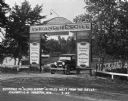
| Description: | Car parked underneath the entrance gate to the Island Resort at the Wisconsin Dells, 25 miles from the Dells on Highway 12-16 near Mauston. Entrance gate a... |
| Date: | 1912 |
|---|---|
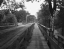
| Description: | A bridge with both a wooden walkway for pedestrians and a dirt road for automobiles. Two men and a horse are standing on the other side of the bridge. |

| Date: | 1925 |
|---|---|
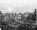
| Description: | View down steep road with guard rail. A car is parked on the side of the road on the right. Over the railing, there is a river and a town with a church bui... |

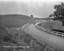
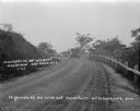
| Date: | 1925 |
|---|---|
| Description: | A view looking up a winding road with rows of utility lines on both sides. The road is partially fenced. |

| Date: | |
|---|---|
| Description: | View down curving road of a car driving towards the lone house in the distance. |

| Date: | |
|---|---|
| Description: | View down road of entrance of bridge. A car is driving towards the viewer. Signs at the bridge entrance read: "Parking on the Bridge is Prohibited," "Wisco... |

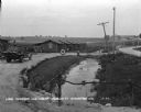
| Date: | |
|---|---|
| Description: | View across street of a storefront at a snowy intersection. |
| Date: | 1921 |
|---|---|
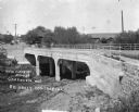
| Description: | View from opposite bank of two horse-drawn buggies crossing the newly constructed bridge over a river. |
| Date: | 1912 |
|---|---|
| Description: | View from road of a man posing on the pedestrian walkway of a metal bridge. There are houses on a hill on the other side of the bridge. |
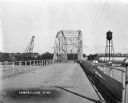
| Date: | 1927 |
|---|---|
| Description: | View down middle of metal bridge across the Cornell Flowage. Across the lake, there is the pulpwood stacker on the left and a water tower on the right near... |
| Date: | 1920 |
|---|---|
| Description: | View from hillside of car driving down a winding road. Their are cornfields on both sides of the road. |

| Date: | 1925 |
|---|---|
| Description: | View down the road leading to the PET evaporated milk factory. A painted sign on the factory's exterior wall claims PET evaporated milk is "milk at its bes... |
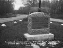
| Date: | 1920 |
|---|---|
| Description: | A stone monument dedicated to the Old Lead Road. The marker reads: "The Old Lead Road. In 1828, ox-teams, guided along an ancient Winnebago Indian Trail, b... |
| Date: | 1927 |
|---|---|
| Description: | An automobile traveling up the dirt road to Wildcat Mountain. There is a guardrail along the road on the right. |

| Date: | 1909 |
|---|---|
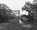
| Description: | A view from shoreline below a bridge that crosses the Wisconsin River. There are two signs on the upper level of the bridge. One is for weight limit and th... |
| Date: | 1930 |
|---|---|
| Description: | View from driveway over a stream towards a row of six log cabins to the left Highway 51. A Texaco Station and a delivery truck are on the far left. Cars ar... |

| Date: | 1922 |
|---|---|
| Description: | View from road of a bluff with exposed rock face next to a winding unpaved road (probably Hwy 33 up to Wildcat Mountain). There is a guardrail along the cu... |
If you didn't find the material you searched for, our Library Reference Staff can help.
Call our reference desk at 608-264-6535 or email us at: