 Filter: Categories of Wisconsin Historical Images
Filter: Subject of Grist mills
Filter: Year of 1800-1899
Filter: Subject of cities and towns
Filter: Categories of Wisconsin Historical Images
Filter: Subject of Grist mills
Filter: Year of 1800-1899
Filter: Subject of cities and towns
| Date: | 1896 |
|---|---|
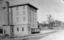
| Description: | Flour and grist mill built on Green Lake Prairie and later moved to Alto. It stood about 50 feet tall and 24 feet wide. |
| Date: | 1885 |
|---|---|
| Description: | View of the Rockdale mill, a grist and sawmill built in 1847 by Thomas and Nathan Van Horn. A group of people are standing on a sidewalk or loading dock on... |

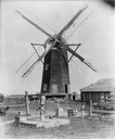
| Date: | 1872 |
|---|---|
| Description: | Wind powered stone grist mill. Two men stand on a wood balcony near the open doorway of the windmill. |
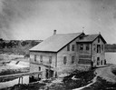
| Date: | 1880 |
|---|---|
| Description: | View across water towards the Hull mill (right), showing Merlin Hull's ancestral home at left. |

| Date: | 1853 |
|---|---|
| Description: | Farwell's Mill on the Yahara River at Lake Mendota. |

| Date: | 1860 |
|---|---|
| Description: | View of the Rock River with a train on a railroad bridge in the foreground, and the town in the distance. Pedestrians are walking along a path on the left ... |
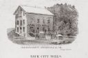
| Date: | 1880 |
|---|---|
| Description: | Exterior view of a mill, with several figures and horse-drawn vehicles located around it. Caption reads: "Sauk City Mills." |

| Date: | 1835 |
|---|---|
| Description: | Ink on tracing paper map of Green Bay, Wisconsin and nearby areas, Lake Winnebago, Fox and Wolf Rivers, and the junctions of the Mississippi and Wisconsin ... |

| Date: | 1858 |
|---|---|
| Description: | This map of Wisconsin and Minnesota shows proposed railroads, copper mines, marshes, villages, mills, reefs, notes about shorelines, and references to mini... |
| Date: | 1850 |
|---|---|
| Description: | A grist mill on the Yahara River at the outlet of Lake Mendota. The mill, called Farwell's Madison Mills was built in 1850 by Governor Farwell. The origina... |

| Date: | 1884 |
|---|---|
| Description: | Page one of a Sanborn map of River Falls, Wisconsin. |

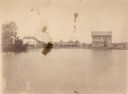
| Date: | 1875 |
|---|---|
| Description: | Elevated view of several buildings, with bridge and railroad tracks, and the Fox River. In the foreground on the right is the Commercial House, with three ... |
If you didn't find the material you searched for, our Library Reference Staff can help.
Call our reference desk at 608-264-6535 or email us at:
