 Filter: Categories of Wisconsin Historical Images
Filter: Subject of Grist mills
Filter: County of Brown
Filter: Categories of Wisconsin Historical Images
Filter: Subject of Grist mills
Filter: County of Brown

| Date: | 1835 |
|---|---|
| Description: | Ink on tracing paper map of Green Bay, Wisconsin and nearby areas, Lake Winnebago, Fox and Wolf Rivers, and the junctions of the Mississippi and Wisconsin ... |
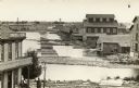
| Date: | 1910 |
|---|---|
| Description: | Photographic postcard of elevated view of the back of mills lining the bridge. Coal kilns are below the hand-drawn arrow at top right. "Sawmills, gristmill... |

| Date: | 1900 |
|---|---|
| Description: | This photostat map shows private claim owners, natural meadows, roads, saw and grist mills, and Fort Howard. The upper right corner includes annotations an... |

| Date: | 1875 |
|---|---|
| Description: | Elevated view of several buildings, with bridge and railroad tracks, and the Fox River. In the foreground on the right is the Commercial House, with three ... |
If you didn't find the material you searched for, our Library Reference Staff can help.
Call our reference desk at 608-264-6535 or email us at: