 Filter: Categories of Wisconsin Historical Images
Filter: Subject of Great Lakes
Filter: Year of 1900-1999
Filter: Year of 1930-1939
Filter: Categories of Wisconsin Historical Images
Filter: Subject of Great Lakes
Filter: Year of 1900-1999
Filter: Year of 1930-1939

| Date: | 1930 |
|---|---|
| Description: | Page 8 of the 1930 schedule is a map of the routes of the Goodrich Steamship Lines in Lake Michigan and Lake Huron. |
| Date: | 1930 |
|---|---|
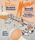
| Description: | Cover from schedule showing passengers relaxing on the deck of a screw-driven passenger/freight vessel. |
| Date: | 07 04 1931 |
|---|---|
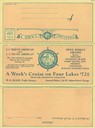
| Description: | Front of dinner menu for the "North American" for the season. Gives rates for cruises on the "North American" or "South American" between Chicago, Illinois... |

| Date: | 07 04 1931 |
|---|---|
| Description: | Inside of Saturday dinner menu for the "North American." Includes drawings of Niagara Falls, New York, Old Fort Mackinac Island, Michigan, Michigan Bouleva... |
| Date: | 1931 |
|---|---|
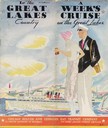
| Description: | Cover of the Chicago, Duluth and Georgian Bay Transit Company schedule in the Great Lakes Country, depicts a man and a woman watching a ship; either the "N... |
| Date: | 1936 |
|---|---|
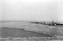
| Description: | Elevated view of logs tugged across Lake Superior to the harbor at Ashland. |

| Date: | 1939 |
|---|---|
| Description: | A color, pictorial map. Scale: 10 miles to the inch. Shows state parks and forests, proposed state parkways, proposed state monuments and memorials, nation... |

| Date: | 1937 |
|---|---|
| Description: | Official state highway map, with insets of cities. |

| Date: | 1934 |
|---|---|
| Description: | An original lithograph promoting Niagara Falls as the place "Where the Great Lakes Leap to the Sea, Travel by Train." Featuring the artist Fredric C. Madan... |
| Date: | 1936 |
|---|---|
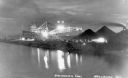
| Description: | Unloading coal from a large ship in Lake Superior onto land near Washburn. There is a large conveyor that has lights glowing in the dark sky. A large pile ... |
| Date: | 1930 |
|---|---|
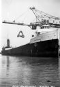
| Description: | View of the ship "Alex B. Uhrig" in the process of coal unloading on the Reiss Coal Dock No. 2. |

| Date: | 1935 |
|---|---|
| Description: | View of six men sitting on rattan furniture on a covered boat deck. Three men are wearing hats, and one man is smoking a cigar. Off the bow of the boat an ... |

| Date: | 1938 |
|---|---|
| Description: | This tourist map of Door County, Wisconsin, lists the points of interest and resorts in the area. An inset location map is included. |

| Date: | 1930 |
|---|---|
| Description: | "Issued by Door County Chamber of Commerce." Shows federal system highways, state highways, county trunk highways, country roads, and parks. Includes direc... |

| Date: | 1934 |
|---|---|
| Description: | This map shows industrial points of interest in Superior. The top of the map reads: "Superior, Douglas County, Wisconsin, as this Industrial Tour map indic... |

| Date: | 1936 |
|---|---|
| Description: | This map shows the state trunk highway system and county trunk highways. This map show surface type on state and county trunk highways and the locations of... |

| Date: | 1936 |
|---|---|
| Description: | This map shows road surfaces, construction, flying fields, seaplane landings, populations of cities and towns, and ferry routes of Wisconsin and some of th... |

| Date: | 1937 |
|---|---|
| Description: | This map shows the major roads, cities, towns, lakes, and rivers of Wisconsin and some of the neighboring states. The front includes an add for Coca-Cola, ... |

| Date: | 1937 |
|---|---|
| Description: | This map shows the major cities, towns, highways, roads, lakes, and rivers of Wisconsin and some of the neighboring states. An index is included on the fro... |

| Date: | 1935 |
|---|---|
| Description: | This colored road map comes with a map legend and explanation, as well as an index of cities and towns (and their populations) in Wisconsin. Information ab... |
If you didn't find the material you searched for, our Library Reference Staff can help.
Call our reference desk at 608-264-6535 or email us at: