 Filter: Categories of Wisconsin Historical Images
Filter: Subject of Great Lakes
Filter: Subject of water
Filter: Reproduction Rights of Special Conditions
Filter: Categories of Wisconsin Historical Images
Filter: Subject of Great Lakes
Filter: Subject of water
Filter: Reproduction Rights of Special Conditions

| Date: | 1688 |
|---|---|
| Description: | This map includes vignettes of Amerindian life with text describing geography, culture, and exploration activity, written in French. The Great Lakes, river... |

| Date: | 1755 |
|---|---|
| Description: | Hand-colored. Paris: 1755. Scale [ca. 1:3,000,000]. |

| Date: | 2013 |
|---|---|
| Description: | Map is the most extensive endeavor to date to accurately locate and document both prehistoric place names and natural features of the Menominee language wi... |
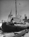
| Date: | 02 18 1958 |
|---|---|
| Description: | The SS Meteor, a Great Lakes cargo steamship of whaleback design, coming into harbor. The ship is covered with snow and ice and the surface of the l... |
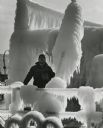
| Date: | 01 1969 |
|---|---|
| Description: | Spray from the lake has built up as thick ice on a ship, creating interesting shapes. A man is standing on the deck. |
If you didn't find the material you searched for, our Library Reference Staff can help.
Call our reference desk at 608-264-6535 or email us at:
