 Filter: Categories of Wisconsin Historical Images
Filter: Subject of Great Lakes
Filter: Subject of water
Filter: Creator Name of Unknown
Filter: Categories of Wisconsin Historical Images
Filter: Subject of Great Lakes
Filter: Subject of water
Filter: Creator Name of Unknown

| Date: | 1823 |
|---|---|
| Description: | In 1823 U.S. Army major Stephen H. Long led an expedition of scientific, trade, and military investigation up the Mississippi River and the Red River of th... |
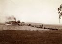
| Date: | 1904 |
|---|---|
| Description: | View from shoreline of the steamboat "Plowboy" approaching the Mission Dock at La Pointe. The Plowboy was the first steam ferry to go to Madeline Island. T... |
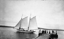
| Date: | 1900 |
|---|---|
| Description: | Sailboat Lizzie W. at the Mission Dock. Captain Daniel Russell Angus, in the white sleeves, is at the tiller. The boat was named after Elizabeth Woo... |
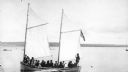
| Date: | 1900 |
|---|---|
| Description: | Group of people on sailboat "Alpha" at dock on Madeline Island. Captain Daniel Angus is at the tiller. |

| Date: | 1900 |
|---|---|
| Description: | View of La Pointe, Madeline Island, taken from the Mission Inn. |

| Date: | 1900 |
|---|---|
| Description: | The house of Captain Angus on the shore of Lake Superior in La Pointe on Madeline Island sometime around 1900. The Angus family came to Madeline Island in ... |
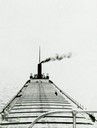
| Date: | 1910 |
|---|---|
| Description: | Lake Michigan freighter with smoke billowing from smokestack. View from from bow looking back toward stern. |

| Date: | 1697 |
|---|---|
| Description: | Father Hennepin's map in French of the upper lakes. |

| Date: | 1930 |
|---|---|
| Description: | Page 8 of the 1930 schedule is a map of the routes of the Goodrich Steamship Lines in Lake Michigan and Lake Huron. |
| Date: | 1880 |
|---|---|
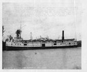
| Description: | The screw passenger and freight vessel, Manistee. Faint typing on picture describes the loss of the Manistee on November 16, 1883. The ship <... |

| Date: | 07 04 1931 |
|---|---|
| Description: | Inside of Saturday dinner menu for the "North American." Includes drawings of Niagara Falls, New York, Old Fort Mackinac Island, Michigan, Michigan Bouleva... |
| Date: | |
|---|---|
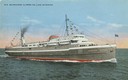
| Description: | The screw passenger and freight vessel, S.S. Milwaukee Clipper, on Lake Michigan. Originally named Juniata. |

| Date: | |
|---|---|
| Description: | An early whaleback freight steamship on the Great Lakes. The captain was William M. Bates. |

| Date: | 1862 |
|---|---|
| Description: | Drawn the second year of the Civil War, this 1862 map of Milwaukee shows post offices, light houses, beacon lights, county buildings, elevator warehouses, ... |

| Date: | 1905 |
|---|---|
| Description: | Bird's-eye view of Manitowoc on the shores of Lake Michigan. A map of the northeastern part of the United States at the top indicates Manitowoc's location ... |
| Date: | 1907 |
|---|---|
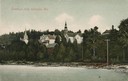
| Description: | View from water of beach and buildings in Ephraim. Caption reads: "Greetings from Ephraim, Wis." |
| Date: | |
|---|---|
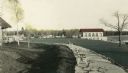
| Description: | Hand-colored view of the Thordarson estate including the boathouse and a stone-paved path with benches. |

| Date: | 1784 |
|---|---|
| Description: | Map of The United States of America according to the Treaty of Peace of 1784. |
If you didn't find the material you searched for, our Library Reference Staff can help.
Call our reference desk at 608-264-6535 or email us at:

