 Filter: Categories of Wisconsin Historical Images
Filter: Subject of Great Lakes
Filter: Subject of intellectual life
Filter: Categories of Wisconsin Historical Images
Filter: Subject of Great Lakes
Filter: Subject of intellectual life

| Date: | 1892 |
|---|---|
| Description: | Bird's-eye view of the Columbian Exposition pavilions from the vantage point of Lake Michigan. Included is an inset of the Union Passenger Station (now Uni... |

| Date: | |
|---|---|
| Description: | Sketch of the Fort at Michilimackinac (also called Mackinac) as it was under French rule. |
| Date: | |
|---|---|
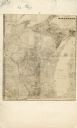
| Description: | Carte-de-visite map of Wisconsin. Broken down into a grid, and includes some topography and Lake Michigan. The letters "M.C." have been written on top of t... |

| Date: | 1970 |
|---|---|
| Description: | Aerial view of International Harvester's Wisconsin Steel Works, with a river and Lake Michigan in the background. |

| Date: | 1884 |
|---|---|
| Description: | Cover art for a pamphlet advertising The Apostle Islands and Lake Superior. The upper half of the artwork depicts a sunset view of Lake Superior, and the b... |

| Date: | 1887 |
|---|---|
| Description: | A bird's-eye map of Menekaune, Menominee and Marinette. |
| Date: | |
|---|---|
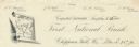
| Description: | Numbered letterhead of the First National Bank, with a map of Wisconsin and a starred location marker for Chippewa Falls, a medallion, and a flowering stal... |

| Date: | 1891 |
|---|---|
| Description: | Color illustration of the grounds and buildings of the 1893 World's Fair or Columbian Exposition. |

| Date: | 1873 |
|---|---|
| Description: | A hand-colored, geological map of the Fox and Wisconsin rivers’ water path from the Mississippi River to the Great Lakes. The map also shows those railroad... |

| Date: | 1836 |
|---|---|
| Description: | This map depicts Wisconsin and Michigan territories in 1836. It includes the area from Michigan to the Missouri River and Lake Winnipeg, and it shows the e... |

| Date: | 02 1823 |
|---|---|
| Description: | A map featuring the North American expedition from Pittsburgh to the Rocky Mountains led by Edwin James. |

| Date: | 1952 |
|---|---|
| Description: | Map of the barley-growing regions of North America, published by the Rahr Malting Company, Manitowoc, Wisconsin, 1952. |
| Date: | 1900 |
|---|---|
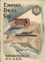
| Description: | Catalog cover featuring an illustration of an Empire Drill on a map of the northeast United States. A railroad train is traveling east to west from Albany ... |
| Date: | 1901 |
|---|---|
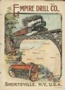
| Description: | Catalog cover with the title: "The Three Greatest Empires," features an illustration of an Empire Drill in the foreground, and in the background a train tr... |

| Date: | 06 14 1961 |
|---|---|
| Description: | Aerial view of North and South Harbor Tracts, looking north from South Pier No. 2. There are skyscrapers in the background. there are multiple items of mac... |

| Date: | |
|---|---|
| Description: | Aerial view of harbor. In the foreground is a lighthouse and breakwaters. Bridges cross the harbor, and there are factory and industrial buildings near the... |

| Date: | |
|---|---|
| Description: | Aerial view of harbor, with shipyards in the foreground and Superior in the background. Caption reads: "Aerial View of Harbor, Superior, Wisconsin." |

| Date: | |
|---|---|
| Description: | Aerial view of Marinette Harbor looking out towards Lake Superior. A lighthouse and breakwater extend out into the lake. Industrial buildings, cranes, and ... |
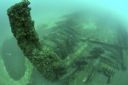
| Date: | 2015 |
|---|---|
| Description: | Underwater view of algae and mussels covering the wood skeletal frame of the Advance, a schooner built in 1853 and sunk in 1885. Most of the frame i... |
If you didn't find the material you searched for, our Library Reference Staff can help.
Call our reference desk at 608-264-6535 or email us at:
