 Filter: Categories of Wisconsin Historical Images
Filter: Subject of Great Lakes
Filter: Subject of intellectual life
Filter: County of Milwaukee
Filter: Categories of Wisconsin Historical Images
Filter: Subject of Great Lakes
Filter: Subject of intellectual life
Filter: County of Milwaukee

| Date: | 07 1959 |
|---|---|
| Description: | Dickey Chapelle, photographer, on the same Milwaukee beach where she learned to swim as a young girl. She was covering "Operation Inland Seas" celebrating ... |

| Date: | 1898 |
|---|---|
| Description: | Bird's-eye map, looking west from shoreline on Lake Michigan of Milwaukee to Golden Lake in Waukesha County, with Kenosha and Fox Point at bottom corners, ... |

| Date: | 1927 |
|---|---|
| Description: | Color map, hand-drawn with comic figures engaged in various activities throughout map. Bordered by the river on the left and Lake Michigan on the right, in... |

| Date: | 06 14 1961 |
|---|---|
| Description: | Aerial view of North and South Harbor Tracts, looking north from South Pier No. 2. There are skyscrapers in the background. there are multiple items of mac... |
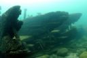
| Date: | 08 2007 |
|---|---|
| Description: | Underwater view of the Apomattox's floor keelsons near the bow. |
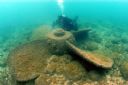
| Date: | 2006 |
|---|---|
| Description: | Underwater view of a propeller located off of the Appomattox wreck site, near Shorewood, in Lake Michigan. The diver is Kimm Stabelfeldt. |
If you didn't find the material you searched for, our Library Reference Staff can help.
Call our reference desk at 608-264-6535 or email us at: