 Filter: Categories of Wisconsin Historical Images
Filter: Subject of Great Lakes
Filter: Subject of intellectual life
Filter: Creator Name of Unknown
Filter: Categories of Wisconsin Historical Images
Filter: Subject of Great Lakes
Filter: Subject of intellectual life
Filter: Creator Name of Unknown
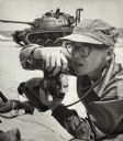
| Date: | 07 1959 |
|---|---|
| Description: | Dickey Chapelle, photographer, on the same Milwaukee beach where she learned to swim as a young girl. She was covering "Operation Inland Seas" celebrating ... |

| Date: | 1823 |
|---|---|
| Description: | In 1823 U.S. Army major Stephen H. Long led an expedition of scientific, trade, and military investigation up the Mississippi River and the Red River of th... |

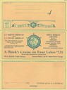
| Date: | 1926 |
|---|---|
| Description: | Pages 21 and 22 from the 1926 schedule are a map showing the routes of the Goodrich Transit Company, Great Lakes Transit Company, Detroit and Cleveland Lin... |

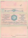
| Date: | 1930 |
|---|---|
| Description: | Page 8 of the 1930 schedule is a map of the routes of the Goodrich Steamship Lines in Lake Michigan and Lake Huron. |
| Date: | 07 04 1931 |
|---|---|
| Description: | Front of dinner menu for the "North American" for the season. Gives rates for cruises on the "North American" or "South American" between Chicago, Illinois... |

| Date: | 07 04 1931 |
|---|---|
| Description: | Inside of Saturday dinner menu for the "North American." Includes drawings of Niagara Falls, New York, Old Fort Mackinac Island, Michigan, Michigan Bouleva... |
| Date: | 1928 |
|---|---|
| Description: | Front of Tuesday luncheon menu for the "South American" for season. Gives rates for cruises on the "North American" or "South American" between Chicago, Il... |

| Date: | 1905 |
|---|---|
| Description: | Bird's-eye view of Manitowoc on the shores of Lake Michigan. A map of the northeastern part of the United States at the top indicates Manitowoc's location ... |

| Date: | |
|---|---|
| Description: | Sketch of the Fort at Michilimackinac (also called Mackinac) as it was under French rule. |

| Date: | 1887 |
|---|---|
| Description: | A bird's-eye map of Menekaune, Menominee and Marinette. |
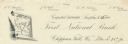
| Date: | |
|---|---|
| Description: | Numbered letterhead of the First National Bank, with a map of Wisconsin and a starred location marker for Chippewa Falls, a medallion, and a flowering stal... |

| Date: | 02 1823 |
|---|---|
| Description: | A map featuring the North American expedition from Pittsburgh to the Rocky Mountains led by Edwin James. |

| Date: | |
|---|---|
| Description: | Aerial view of harbor. In the foreground is a lighthouse and breakwaters. Bridges cross the harbor, and there are factory and industrial buildings near the... |

| Date: | |
|---|---|
| Description: | Aerial view of harbor, with shipyards in the foreground and Superior in the background. Caption reads: "Aerial View of Harbor, Superior, Wisconsin." |

| Date: | |
|---|---|
| Description: | Aerial view of Marinette Harbor looking out towards Lake Superior. A lighthouse and breakwater extend out into the lake. Industrial buildings, cranes, and ... |

| Date: | |
|---|---|
| Description: | Drawing of a map showing the cruise routes from Eagle Inn Dock and the points of interest. There is a schedule and rates on the reverse. |
If you didn't find the material you searched for, our Library Reference Staff can help.
Call our reference desk at 608-264-6535 or email us at: