 Filter: Categories of Wisconsin Historical Images
Filter: Subject of Great Lakes
Filter: Subject of human settlements
Filter: Subject of land
Filter: Year of 1900-1999
Filter: Categories of Wisconsin Historical Images
Filter: Subject of Great Lakes
Filter: Subject of human settlements
Filter: Subject of land
Filter: Year of 1900-1999

| Date: | 1900 |
|---|---|
| Description: | View of La Pointe, Madeline Island, taken from the Mission Inn. |

| Date: | 1900 |
|---|---|
| Description: | The house of Captain Angus on the shore of Lake Superior in La Pointe on Madeline Island sometime around 1900. The Angus family came to Madeline Island in ... |

| Date: | 1926 |
|---|---|
| Description: | Map of the routes of the screw-driven passenger/freight vessels of the Michigan Transit Company for 1926. |

| Date: | 07 04 1931 |
|---|---|
| Description: | Inside of Saturday dinner menu for the "North American." Includes drawings of Niagara Falls, New York, Old Fort Mackinac Island, Michigan, Michigan Bouleva... |

| Date: | 1928 |
|---|---|
| Description: | Inside of Tuesday luncheon menu for the "South American." Includes drawings of Niagara Falls, New York, Old Fort Mackinac Island, Michigan, Michigan Boulev... |

| Date: | 1913 |
|---|---|
| Description: | Bird's-eye map of Superior. "The New Steel Center." |

| Date: | 1915 |
|---|---|
| Description: | Bird's-eye view of Superior, Wisconsin, and Duluth, Minnesota on opposite shore of Lake Superior. |

| Date: | 1910 |
|---|---|
| Description: | Bird's-eye view looking east, with Washburn Harbor at center and Chequamegon Bay in Lake Superior covering most of the upper image. Streets with buildings... |

| Date: | 1918 |
|---|---|
| Description: | "The playground of the Middle West." Showing the Numbered and Marked State Trunk Highway System and the Principal Secondary Highways; also locates Points o... |

| Date: | 1910 |
|---|---|
| Description: | Wisconsin Geological and Natural History Survey, by Lawrence Martin reproduced from a model of the state prepared by W.O. Hotchkiss and F.T. Thwaites and m... |

| Date: | 1913 |
|---|---|
| Description: | Wisconsin map showing fifteen hundred miles of national highways proposed by the National Highways Association. Scale: 1:2,500,000. These highways will dir... |

| Date: | 1918 |
|---|---|
| Description: | A map of primarily of Wisconsin, but also includes the areas of northern Illinois, eastern portions of Minnesota and Iowa, and Michigan’s Upper Peninsula, ... |

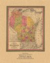
| Date: | 1908 |
|---|---|
| Description: | A map of Wisconsin showing cities and towns, rivers, lakes, and railroads. Other areas included in the map are the western portion of Michigan's Upper Pen... |

| Date: | 1915 |
|---|---|
| Description: | A map of Wisconsin that shows 1,900 miles of national highways proposed for the state. The map also includes the names and locations of towns and cities th... |

| Date: | 1956 |
|---|---|
| Description: | A map depicting the for systems of land description in Wisconsin, which include metes and bounds, U.S. System of Rectangular Surveys, Latitude and longitud... |
| Date: | 1974 |
|---|---|
| Description: | A map that was originally published around 1851 in S. Augustus Mitchell's New universal atlas, shows portions of present-day Iron and Vilas counties north ... |

| Date: | 1911 |
|---|---|
| Description: | This map of Wisconsin, the western portion of Michigan's Upper Peninsula, and northern Illinois shows counties, towns, cities and villages, rivers and lake... |

| Date: | 1910 |
|---|---|
| Description: | Chart of Lake Michigan noting soundings near shore and across the lake between harbors. Also included are portions of Wisconsin, Michigan, Illinois, Indian... |
If you didn't find the material you searched for, our Library Reference Staff can help.
Call our reference desk at 608-264-6535 or email us at:

