 Filter: Categories of Wisconsin Historical Images
Filter: Subject of Great Lakes
Filter: Subject of cities and towns
Filter: County of Milwaukee
Filter: Categories of Wisconsin Historical Images
Filter: Subject of Great Lakes
Filter: Subject of cities and towns
Filter: County of Milwaukee
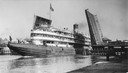
| Date: | 08 30 1906 |
|---|---|
| Description: | A screw passenger excursion vessel or whaleback, the Christopher Columbus, passing through the Broadway Bridge. |

| Date: | 1862 |
|---|---|
| Description: | Drawn the second year of the Civil War, this 1862 map of Milwaukee shows post offices, light houses, beacon lights, county buildings, elevator warehouses, ... |
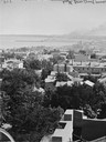
| Date: | |
|---|---|
| Description: | Elevated view south from Courthouse of rooftops, with harbor and bay in distance. |
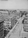
| Date: | |
|---|---|
| Description: | Milwaukee, towards South Point from Mitchell Block, E. Water Street and Michigan Street. Elevated view shows buildings and rooftops with bay and harbor in ... |
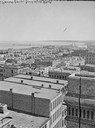
| Date: | |
|---|---|
| Description: | Looking east from Mitchell Block. Elevated view of buildings with the lake and a steamship in the distance. |

| Date: | 1898 |
|---|---|
| Description: | Bird's-eye map, looking west from shoreline on Lake Michigan of Milwaukee to Golden Lake in Waukesha County, with Kenosha and Fox Point at bottom corners, ... |

| Date: | 1927 |
|---|---|
| Description: | Color map, hand-drawn with comic figures engaged in various activities throughout map. Bordered by the river on the left and Lake Michigan on the right, in... |

| Date: | 06 14 1961 |
|---|---|
| Description: | Aerial view of North and South Harbor Tracts, looking north from South Pier No. 2. There are skyscrapers in the background. there are multiple items of mac... |

| Date: | 1964 |
|---|---|
| Description: | View across water towards the tugboat "Indiana" pulling the full-rigged, three-masted Norwegian ship "Christian Radich" into port. The sails and hull of th... |
If you didn't find the material you searched for, our Library Reference Staff can help.
Call our reference desk at 608-264-6535 or email us at: