 Filter: Categories of Wisconsin Historical Images
Filter: Subject of Great Lakes
Filter: Subject of cities and towns
Filter: Creator Name of Unknown
Filter: Categories of Wisconsin Historical Images
Filter: Subject of Great Lakes
Filter: Subject of cities and towns
Filter: Creator Name of Unknown

| Date: | 1900 |
|---|---|
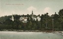
| Description: | View of La Pointe, Madeline Island, taken from the Mission Inn. |

| Date: | 1900 |
|---|---|
| Description: | The house of Captain Angus on the shore of Lake Superior in La Pointe on Madeline Island sometime around 1900. The Angus family came to Madeline Island in ... |

| Date: | 1926 |
|---|---|
| Description: | Map of the routes of the screw-driven passenger/freight vessels of the Michigan Transit Company for 1926. |

| Date: | 07 04 1931 |
|---|---|
| Description: | Inside of Saturday dinner menu for the "North American." Includes drawings of Niagara Falls, New York, Old Fort Mackinac Island, Michigan, Michigan Bouleva... |

| Date: | 1928 |
|---|---|
| Description: | Inside of Tuesday luncheon menu for the "South American." Includes drawings of Niagara Falls, New York, Old Fort Mackinac Island, Michigan, Michigan Boulev... |

| Date: | 1862 |
|---|---|
| Description: | Drawn the second year of the Civil War, this 1862 map of Milwaukee shows post offices, light houses, beacon lights, county buildings, elevator warehouses, ... |

| Date: | 1905 |
|---|---|
| Description: | Bird's-eye view of Manitowoc on the shores of Lake Michigan. A map of the northeastern part of the United States at the top indicates Manitowoc's location ... |
| Date: | 1907 |
|---|---|
| Description: | View from water of beach and buildings in Ephraim. Caption reads: "Greetings from Ephraim, Wis." |

| Date: | 1784 |
|---|---|
| Description: | Map of The United States of America according to the Treaty of Peace of 1784. |

| Date: | 1878 |
|---|---|
| Description: | A color map detailing Ashland and Bayfield counties, including Lake Superior and the Apostle Islands. |

| Date: | 1887 |
|---|---|
| Description: | A bird's-eye map of Menekaune, Menominee and Marinette. |

| Date: | 1887 |
|---|---|
| Description: | The bay shore of Menominee filled with driftwood. |
| Date: | |
|---|---|
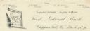
| Description: | Numbered letterhead of the First National Bank, with a map of Wisconsin and a starred location marker for Chippewa Falls, a medallion, and a flowering stal... |

| Date: | 1868 |
|---|---|
| Description: | Wisconsin and parts of Michigan, Minnesota, Illinois and Iowa. It shows cities and towns, drainage, administrative boundaries and the railroad network with... |

| Date: | |
|---|---|
| Description: | An ink, watercolor, and pencil on paper, hand-drawn map that shows the Michigan-Wisconsin boundary in Iron, Vilas, Forest, Florence, and Marinette counties... |

| Date: | 01 06 1958 |
|---|---|
| Description: | View from jetty out towards Lake Michigan entrance to Ship Canal. A large tank, streetlamp and buildings are on the left. On the opposite jetty is a lighth... |

| Date: | 12 10 1957 |
|---|---|
| Description: | Pleasure boat ramps, made of timber, on the south side of Racine Harbor. A man is walking in the snow near the ramps. There are piles of material along the... |

| Date: | 12 20 1957 |
|---|---|
| Description: | View across harbor from small boat ramp towards far shoreline. On the far shoreline is industrial machinery, piles of coal, and other buildings. |
If you didn't find the material you searched for, our Library Reference Staff can help.
Call our reference desk at 608-264-6535 or email us at:

