 Filter: Categories of Wisconsin Historical Images
Filter: Subject of Great Lakes
Filter: Creator Name of Unknown
Filter: Categories of Wisconsin Historical Images
Filter: Subject of Great Lakes
Filter: Creator Name of Unknown

| Date: | 1931 |
|---|---|
| Description: | Cover of the Chicago, Duluth and Georgian Bay Transit Company schedule in the Great Lakes Country, depicts a man and a woman watching a ship; either the "N... |

| Date: | |
|---|---|
| Description: | An early whaleback freight steamship on the Great Lakes. The captain was William M. Bates. |

| Date: | 1862 |
|---|---|
| Description: | Drawn the second year of the Civil War, this 1862 map of Milwaukee shows post offices, light houses, beacon lights, county buildings, elevator warehouses, ... |

| Date: | 1905 |
|---|---|
| Description: | Bird's-eye view of Manitowoc on the shores of Lake Michigan. A map of the northeastern part of the United States at the top indicates Manitowoc's location ... |
| Date: | 1907 |
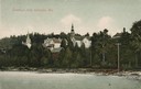
|---|---|
| Description: | View from water of beach and buildings in Ephraim. Caption reads: "Greetings from Ephraim, Wis." |
| Date: | |
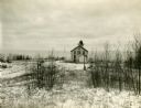
|---|---|
| Description: | Exterior view of the "Pottawatomie" lighthouse in snowy expanse of land, with the lake in the background. |

| Date: | |
|---|---|
| Description: | Sketch of the Fort at Michilimackinac (also called Mackinac) as it was under French rule. |

| Date: | 1761 |
|---|---|
| Description: | A plan of the Straits of St. Mary and Michilimakinac, to shew the situation and importance of the two westernmost settlements of Canada for the fur trade. ... |
| Date: | |
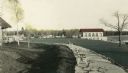
|---|---|
| Description: | Hand-colored view of the Thordarson estate including the boathouse and a stone-paved path with benches. |
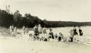
| Date: | 09 07 1927 |
|---|---|
| Description: | Women employees of Thordarson? in bathing suits on the beach during the First Girls Party to Rock Island. |
| Date: | |
|---|---|
| Description: | The stairs and dock at the lighthouse on Rock Island. |

| Date: | 1784 |
|---|---|
| Description: | Map of The United States of America according to the Treaty of Peace of 1784. |

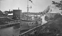
| Date: | |
|---|---|
| Description: | View from shoreline of boats docked at the fishing wharf. People are fishing from the pier, and a group of people are in a rowboat near a ferry. There are ... |
| Date: | |
|---|---|
| Description: | View across water towards a large ferry docked at the fishing wharf. A large group of people are standing on the pier, and passengers are standing at the r... |
| Date: | |
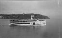
|---|---|
| Description: | View of the steamer ship "Islander" leaving Mackinac Island. Signs painted on the ship reads=: "Islander," "Arnold Line" and "St. Ignace Mackinac Island" (... |
| Date: | |
|---|---|
| Description: | Elevated view of the "City of Charlevoix" ship coming into harbor. The sign painted on the front of the ship reads: "Northern Michigan Line" and "City of C... |

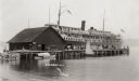
| Date: | 1910 |
|---|---|
| Description: | View of tourists arriving on steamship. Many passengers are on the ship and the dock. |

| Date: | 1856 |
|---|---|
| Description: | A Wisconsin map showing the Wisconsin Superior and St. Croix Railroad. |
If you didn't find the material you searched for, our Library Reference Staff can help.
Call our reference desk at 608-264-6535 or email us at:

