 Filter: Categories of Wisconsin Historical Images
Filter: Subject of Grain elevators
Filter: Subject of railroads
Filter: Categories of Wisconsin Historical Images
Filter: Subject of Grain elevators
Filter: Subject of railroads

| Date: | 1876 |
|---|---|
| Description: | Elevated view showing Elmore and Kelly's Elevator with a boat, train, and the buildings at Fort Howard. Fort Howard was incorporated into Green Bay. Captio... |

| Date: | |
|---|---|
| Description: | View over a train stopped at a grain elevator in the foreground. The Hotel Ristau is across a street on the left, and a church building is in the distance ... |

| Date: | |
|---|---|
| Description: | Letterhead of the Phillip Best Brewing Company of Milwaukee, Wisconsin, with three separate proscenium views of the Empire Brewery, the South Side Brewery,... |

| Date: | 05 1958 |
|---|---|
| Description: | Photocopy of a map created by the City of Milwaukee Master Plan Program City Planning Division in May of 1958 representing 1870 "THE CENTRAL AREA OF THE CI... |
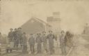
| Date: | 1910 |
|---|---|
| Description: | View of railroad workers posing for a group portrait on the rails. Three men are standing on a handcar. They all are holding the implements they use in the... |

| Date: | 04 15 1916 |
|---|---|
| Description: | Text on front reads: "Depot and Elevator, St. Cloud, Wis." A view up the railroad tracks with the station on the left and grain elevator on the right, with... |

| Date: | 1900 |
|---|---|
| Description: | A Sanborn fire insurance map of Sauk City created in 1900. |
If you didn't find the material you searched for, our Library Reference Staff can help.
Call our reference desk at 608-264-6535 or email us at:
