 Filter: Categories of Wisconsin Historical Images
Filter: Subject of Fortification
Filter: Year of 1900-1999
Filter: Year of 1950-1959
Filter: Categories of Wisconsin Historical Images
Filter: Subject of Fortification
Filter: Year of 1900-1999
Filter: Year of 1950-1959
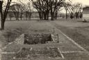
| Date: | 1954 |
|---|---|
| Description: | A view of the site of the original Fort Crawford (1816-1831). |
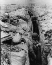
| Date: | 03 25 1954 |
|---|---|
| Description: | Note on the back: "Defenders dig in. Dien Bien Phu, Indochina: An airport once covered this area where soldiers have dug deep trenches as protection from b... |

| Date: | 1950 |
|---|---|
| Description: | Intended for tourists, this brochure features two maps with tourists sites along the Mississippi River. One map shows roads and populated places along the ... |

| Date: | 12 1958 |
|---|---|
| Description: | A soldier in Castro's forces at the battle for the village of LaMaya, Cuba. He is firing from a position known as "The Hole." |

| Date: | 1950 |
|---|---|
| Description: | This map shows regions in Northern Illinois and Southern Wisconsin roughly bounded by Lake Winnebago, the Kankakee River, Peoria, and Prairie du Chien. The... |
If you didn't find the material you searched for, our Library Reference Staff can help.
Call our reference desk at 608-264-6535 or email us at: