Filter: Categories of Wisconsin Historical Images
Filter: Subject of Fortification
Filter: Year of 1900-1999
Filter: Year of 1930-1939
Filter: Categories of Wisconsin Historical Images
Filter: Subject of Fortification
Filter: Year of 1900-1999
Filter: Year of 1930-1939

| Date: | 1936 |
|---|---|
| Description: | This map is red and black ink on tracing cloth and is oriented with north to the upper left. This hand-drawn map shows a central portion of the military ro... |
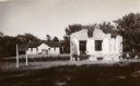
| Date: | 1938 |
|---|---|
| Description: | Annex of Old Fort Howard. Caption reads: "Annex of Old Fort Howard, Green Bay, Wis." |
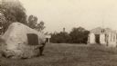
| Date: | 08 1931 |
|---|---|
| Description: | The Beaumont memorial marker on the site of Fort Crawford. |
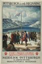
| Date: | 1930 |
|---|---|
| Description: | An original lithograph promoting Pittsburgh, Pennsylvania, and the Pennsylvania Railroad through artist N.C. Wyeth's depiction of the establishment of Fort... |
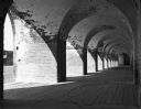
| Date: | 1938 |
|---|---|
| Description: | Light shines through the arches of a portico onto the walkway of Fort Pulaski, completed in 1847. |
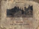
| Date: | 1930 |
|---|---|
| Description: | Holiday card printed on a sheet of copper. It has a scene of log buildings, a stockade fence, and woods in the background. Above is the text "Michigan Copp... |

| Date: | 1930 |
|---|---|
| Description: | This map shows a plat of the town, local streets, railroads, creeks, part of Fox River, and part of the bay of Green Bay. The location of the original fort... |

| Date: | 07 28 1934 |
|---|---|
| Description: | This map shows buildings and dimensions of Fort Crawford and hospital overlaid on a plat of existing lots, streets, and closed streets. |

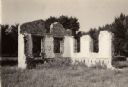
| Date: | 1938 |
|---|---|
| Description: | A horizontal view of the palisade between old Fort Crawford and the military hospital. The number "30" has been placed in the trench on the left. |
If you didn't find the material you searched for, our Library Reference Staff can help.
Call our reference desk at 608-264-6535 or email us at: