 Filter: Categories of Wisconsin Historical Images
Filter: Subject of Fortification
Filter: Subject of water
Filter: Subject of cities and towns
Filter: Categories of Wisconsin Historical Images
Filter: Subject of Fortification
Filter: Subject of water
Filter: Subject of cities and towns

| Date: | 1936 |
|---|---|
| Description: | This map is red and black ink on tracing cloth and is oriented with north to the upper left. This hand-drawn map shows a central portion of the military ro... |

| Date: | 1851 |
|---|---|
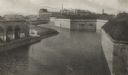
| Description: | A rare photograph of U.S. Army soldiers stationed at Fort Howard rowing a boat on the Fox River. Fort Howard, built in 1816, was the first in the chain of ... |

| Date: | 06 24 1849 |
|---|---|
| Description: | Original wash drawing of Fort Laramie, Wyoming (actually Fort John; see note below). Sketched by Wilkins on his 151-day journey from Missouri to California... |

| Date: | 1876 |
|---|---|
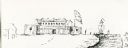
| Description: | Elevated view showing Elmore and Kelly's Elevator with a boat, train, and the buildings at Fort Howard. Fort Howard was incorporated into Green Bay. Captio... |

| Date: | 1851 |
|---|---|
| Description: | View of five soldiers rowing in a boat, beside a dock, with another soldier standing on the dock. The fort is in the background, complete with the fortifie... |
| Date: | |
|---|---|
| Description: | View of a fort with fortified walls and a flag flying from the fort. A river runs on the right of the image. A boat with sails floats on the river. Sold... |

| Date: | 1851 |
|---|---|
| Description: | Several men rowing in a boat near Fort Howard that has an American Flag, barracks, and various related military buildings enclosed behind a wall. |

| Date: | 1830 |
|---|---|
| Description: | Fort Winnebago from an original drawing by Jefferson Davis. |

| Date: | 1840 |
|---|---|
| Description: | Fort Crawford (the second site, with buildings of 1829-?), on the east bank of the Mississippi River, about 2 miles above the mouth of the Wisconsin River. |

| Date: | 1840 |
|---|---|
| Description: | A view of Fort Crawford (the second site and buildings of 1829-?). |

| Date: | 1829 |
|---|---|
| Description: | Fort Crawford, from a sketchbook attributed to Seth Eastman, 1808-1875. A graduate of West Point, Eastman briefly served at Fort Crawford, 1829-1839. |

| Date: | 1855 |
|---|---|
| Description: | Fox-Wisconsin portage and canal map, when the canal was not yet built. From a map in the office of the city clerk at Portage. "The old trail, the location ... |

| Date: | 1831 |
|---|---|
| Description: | Fort Winnebago, a print published in Mrs. John H. Kinzie's Wau-bun (1856). |
| Date: | 04 1862 |
|---|---|
| Description: | Stationery depicting the fortifications around Washington, D.C., during the second year of the Civil War: Arlington Heights, directly across the Potomac Ri... |
| Date: | |
|---|---|
| Description: | View of Chicago from Chicago River. The homes of John Dean, J. Baptiste Beaubien, Dr. Walcott, and John Kinzie are identified by number. Fort Dearborn can ... |

| Date: | |
|---|---|
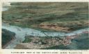
| Description: | Elevated view of Fort Seward from Mount Rippinsky, showing Pyramid Harbor and Davidson Glacier in distance. Caption reads: "Haines and Fort Wm. H. Seward f... |

| Date: | 1864 |
|---|---|
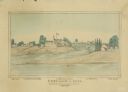
| Description: | View across the Tennessee River toward the city and Cameron Hill, showing the military bridge and some Union Army installations put up following the occupa... |
| Date: | |
|---|---|
| Description: | The old fortifications at Fort Monroe, built to defend Hampton Roads and the mouth of the James River. Jefferson Davis was imprisoned here from 1865 to 186... |
| Date: | |
|---|---|
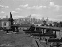
| Description: | A view of artillery and guns at Fort Jay, built in 1794 to defend Upper New York Bay. The New York cityscape is across the bay. |
If you didn't find the material you searched for, our Library Reference Staff can help.
Call our reference desk at 608-264-6535 or email us at:
