 Filter: Categories of Wisconsin Historical Images
Filter: Subject of Fortification
Filter: Subject of service industries
Filter: Categories of Wisconsin Historical Images
Filter: Subject of Fortification
Filter: Subject of service industries

| Date: | 1941 |
|---|---|
| Description: | This pictorial map of Wisconsin with historical text highlights the history of the state and identifies places of interest, Indian villages, missions, trad... |

| Date: | 1950 |
|---|---|
| Description: | Intended for tourists, this brochure features two maps with tourists sites along the Mississippi River. One map shows roads and populated places along the ... |

| Date: | 1853 |
|---|---|
| Description: | This map shows camps, forts, logging camps, lakes, roads, railroads, the Wisconsin River, and Lac Du Flambeau Indian Reservation. Some points of interest a... |
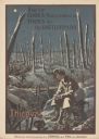
| Date: | 1919 |
|---|---|
| Description: | Poster with an illustration of a British soldier sitting on a battlefield near a trench with barb wire among many destroyed trees at night. There are birds... |
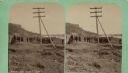
| Date: | 04 18 1888 |
|---|---|
| Description: | Stereograph of fireplace ruins on the site of an old French fort, possibly built by Nicholas Perrot. There is an electric pole behind the fireplace and a g... |
If you didn't find the material you searched for, our Library Reference Staff can help.
Call our reference desk at 608-264-6535 or email us at: