 Filter: Categories of Wisconsin Historical Images
Filter: Subject of Fortification
Filter: Subject of land use, rural
Filter: Categories of Wisconsin Historical Images
Filter: Subject of Fortification
Filter: Subject of land use, rural
| Date: | 1940 |
|---|---|
| Description: | Photograph of a painting by Cal Peters depicting construction of the first Fort Crawford at Prairie du Chien, Wisconsin in 1816. In the painting, several o... |
| Date: | |
|---|---|
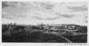
| Description: | Photographic copy of a painting depicting Fort Winnebago, made by I. A. Ridgway of Portage, Wisconsin. Fort Winnebago was built in 1827 by Major William W... |
| Date: | 1898 |
|---|---|
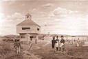
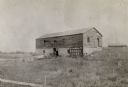
| Description: | Ruins of the commissary warehouse at Fort Winnebago, about 1898. Fort Winnebago was closed in 1845 and the land and buildings sold. Today, only the Surgeon... |

| Date: | 1829 |
|---|---|
| Description: | Hand-colored lithograph of Fort Armstrong on Rock Island, based on a drawing by Henry Lewis. Foreground shows a tree floating in the water. |

| Date: | 1829 |
|---|---|
| Description: | Hand-colored lithograph of Fort Armstrong, based on a drawing by Henry Lewis. Includes boats on the Mississippi River. |

| Date: | 1864 |
|---|---|
| Description: | One of the Confederate defenses around the city, with several cannons behind earthworks. A Union soldier stands near one of the cannons. Plate 40 |

| Date: | 1864 |
|---|---|
| Description: | View looking out from one of the Confederate defenses around the outside of the city. Wooden palisades surround the earthworks. Houses and other buildings ... |

| Date: | 1866 |
|---|---|
| Description: | The south bank of the Chattahoochie River with a bridge spanning it. In the foreground are some battlements. Plate 33 |

| Date: | 1840 |
|---|---|
| Description: | This map shows a line of proposed construction for defending the north side of the canal against inundation from the Wisconsin River and location of Fort W... |

| Date: | 1776 |
|---|---|
| Description: | Fairly detailed map of New York City and parts of Long Island. It shows streets, roads, wharves, ferries, ship yards, Fort George and the battery, public b... |
If you didn't find the material you searched for, our Library Reference Staff can help.
Call our reference desk at 608-264-6535 or email us at: