 Filter: Categories of Wisconsin Historical Images
Filter: Subject of Fortification
Filter: Subject of land
Filter: Categories of Wisconsin Historical Images
Filter: Subject of Fortification
Filter: Subject of land
| Date: | |
|---|---|
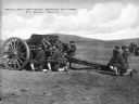
| Description: | A view of soldiers in an open field during artillery practice at The School of Fire, founded in 1911 at Fort Sill. Caption reads: "Artillery Practice, Scho... |
| Date: | |
|---|---|
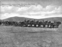
| Description: | A view of horse-drawn artillery at the School of Fire, established in 1911 at Fort Sill. Caption reads: "Artillery Practice, School of Fire, Ft. Sill, OKLA... |

| Date: | |
|---|---|
| Description: | A hand-drawn map including the location of Daniel Boone's home and two forts, northeast of Lexington, Kentucky. |

| Date: | 1866 |
|---|---|
| Description: | Exterior of Fort Sumter. A cannon has fallen on the steep shoreline and waves are hitting the rocks. Plate 58 |

| Date: | 1865 |
|---|---|
| Description: | Exterior of Fort Sumpter [sic]. There are several men and a boat on the shoreline in the foreground. Plate 56 |
| Date: | 1864 |
|---|---|
| Description: | Confederate defenses surrounding the city. A tripod style configuration of rifles with a bag and canteen hanging from it is in the foreground. Plate 43<... |
| Date: | 1864 |
|---|---|
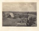
| Description: | One of the Confederate defenses surrounding the city. This view is of the inside of the earthworks which includes two cannons. A Union soldier sits as a lo... |

| Date: | 1864 |
|---|---|
| Description: | View looking out from one of the Confederate defenses around the outside of the city. Wooden palisades surround the earthworks. Houses and other buildings ... |

| Date: | 1866 |
|---|---|
| Description: | The south bank of the Chattahoochie River with a bridge spanning it. In the foreground are some battlements. Plate 33 |
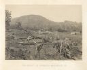
| Date: | 1866 |
|---|---|
| Description: | A fence or battlement, with battered trees overlooking a valley. Kenesaw Mountain is in the distance. |
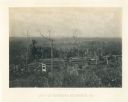
| Date: | 1866 |
|---|---|
| Description: | Earthworks in a field in foreground. In the middle distance is a small house with a fence. The Kenesaw Mountain is in the background. |
| Date: | 1866 |
|---|---|
| Description: | Two men stand on either side of an opening in the earthworks at Allatoona Pass. Mountains are in the distance. Plate 28 |
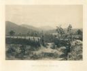
| Date: | 1866 |
|---|---|
| Description: | View towards the Allatoona Pass from behind earthworks overlooking the Etawah River. A railroad bridge crosses the river on the right. Plate 24 |

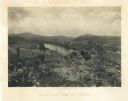
| Date: | 1866 |
|---|---|
| Description: | View along earthworks overlooking the Etawah River and a railroad bridge. A tree stripped of branches and bark is on the left. Plate 23 |

| Date: | 1866 |
|---|---|
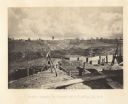
| Description: | View of earthworks at the battlefield at Resacca. Dirt roads cross the field in the distance, leading to a farm and what appears to be a river. Plate 22... |

| Date: | 1864 |
|---|---|
| Description: | View down to valley of Union soldiers posing on the roof of a log building. A log bridge crosses a stream, and many trees are on the hillsides. Plate 05... |

| Date: | 1820 |
|---|---|
| Description: | This map displays the plan for claiming various settlement zones in the Prairie des Chiens area in 1820. It shows Fort Crawford and 87 confirmed and unconf... |
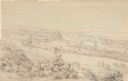
| Date: | 1852 |
|---|---|
| Description: | Landscape view of Fort Snelling, Minnesota Territory from a nearby hill showing the Fort, the Mississippi river, the countryside, farm buildings and tipis.... |

| Date: | 1806 |
|---|---|
| Description: | Prehistoric Indian fortification on Hurricane Creek. |

| Date: | |
|---|---|
| Description: | A map of the prehistoric fort at Circleville with annotations by Daniel Drake. |
If you didn't find the material you searched for, our Library Reference Staff can help.
Call our reference desk at 608-264-6535 or email us at: