 Filter: Categories of Wisconsin Historical Images
Filter: Subject of Fortification
Filter: Subject of intellectual life
Filter: Categories of Wisconsin Historical Images
Filter: Subject of Fortification
Filter: Subject of intellectual life
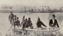
| Date: | 1860 |
|---|---|
| Description: | Nine men arrive at Fort William by canoe. Fort William, also called Kaministiguia, was the Hudson's Bay fur trading post. Men are standing along the opposi... |

| Date: | |
|---|---|
| Description: | A hand-drawn map of the state of Missouri with a separate drawing of a map showing Forts Henry and Donelson. The Missouri map includes Jefferson City and s... |

| Date: | |
|---|---|
| Description: | Sketch of the Fort at Michilimackinac (also called Mackinac) as it was under French rule. |

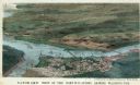
| Date: | 1855 |
|---|---|
| Description: | Fox-Wisconsin portage and canal map, when the canal was not yet built. From a map in the office of the city clerk at Portage. "The old trail, the location ... |
| Date: | 04 1862 |
|---|---|
| Description: | Stationery depicting the fortifications around Washington, D.C., during the second year of the Civil War: Arlington Heights, directly across the Potomac Ri... |

| Date: | 1968 |
|---|---|
| Description: | A woman sits on the grass reading next to a baby carriage in Fort Tyron Park. A brush-covered hill surmounted by a square tower rises in the background. |
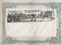
| Date: | 1860 |
|---|---|
| Description: | Scene of 16 figures. A slave owner is raising his whip as black families are racing towards Fort Monroe, with some remaining behind picking cotton. The sla... |
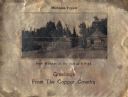
| Date: | 1930 |
|---|---|
| Description: | Holiday card printed on a sheet of copper. It has a scene of log buildings, a stockade fence, and woods in the background. Above is the text "Michigan Copp... |

| Date: | |
|---|---|
| Description: | Valentine's Day card featuring a girl wearing a red uniform and a sword, standing on the roof of a fort. A boy in a tan uniform with a sword, is looking at... |

| Date: | 1806 |
|---|---|
| Description: | Prehistoric Indian fortification on Hurricane Creek. |

| Date: | |
|---|---|
| Description: | A map of the prehistoric fort at Circleville with annotations by Daniel Drake. |
| Date: | 06 23 1832 |
|---|---|
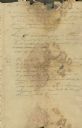
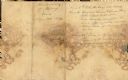
| Description: | Document written by Ebenezer Brigham listing events at Fort Blue Mounds. |
| Date: | 06 23 1832 |
|---|---|
| Description: | Document written by Ebenezer Brighman listing occurrences at Fort Blue Mounds. |
| Date: | 07 1863 |
|---|---|
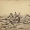
| Description: | Stereograph of three Confederate soldiers captured during the Battle of Gettysburg. This photograph was taken by Mathew Brady a few days after the battle. ... |
| Date: | 07 1863 |
|---|---|
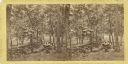
| Description: | A stereograph made by Mathew Brady about two weeks after the battle of Gettysburg, showing his two assistants gazing eastward from the extreme right of the... |

| Date: | 1900 |
|---|---|
| Description: | This manuscript map shows outline of Fort Winnebago reserve land, Fort Winnebago, claim of A. Grignon, and Indian boundaries. The Fox River and Swan Lake a... |

| Date: | 1839 |
|---|---|
| Description: | This map shows the geological makeup of the valley in red, yellow, and green, the Mississippi River, and the location of Fort Crawford. The geology on the ... |

| Date: | 1990 |
|---|---|
| Description: | This map, in addition to the Fort ground and buildings, shows owners of outbuildings, heights of buildings in stories, fences, roads, gardens, and cemetery... |

| Date: | 1719 |
|---|---|
| Description: | This extremely detailed and ornate map shows the cities, Native American land, mountains, lakes, rivers, and European claims of North America. An inset map... |

| Date: | 1755 |
|---|---|
| Description: | Large format map of America and Canada east of the Mississippi River. D'Anville marks the locations of rivers, lakes, settlements, cities, Native American ... |
If you didn't find the material you searched for, our Library Reference Staff can help.
Call our reference desk at 608-264-6535 or email us at: