 Filter: Categories of Wisconsin Historical Images
Filter: Subject of Fortification
Filter: Subject of economics
Filter: Categories of Wisconsin Historical Images
Filter: Subject of Fortification
Filter: Subject of economics

| Date: | 1914 |
|---|---|
| Description: | This photostat map shows Fort Winnebago around 1931, land to be reserved for military purposes, roads to Fort Howard and Fort Crawford, "private property" ... |
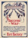
| Date: | 1918 |
|---|---|
| Description: | Poster featuring a cartoon illustration of six long lines of men marching into a factory. Poster text reads: "Success in War — depends on co-operation and ... |
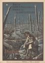
| Date: | 1919 |
|---|---|
| Description: | Poster with an illustration of a British soldier sitting on a battlefield near a trench with barb wire among many destroyed trees at night. There are birds... |
If you didn't find the material you searched for, our Library Reference Staff can help.
Call our reference desk at 608-264-6535 or email us at: