Filter: Categories of Wisconsin Historical Images
Filter: Subject of Fortification
Filter: County of Crawford
Filter: Subject of human settlements
Filter: Categories of Wisconsin Historical Images
Filter: Subject of Fortification
Filter: County of Crawford
Filter: Subject of human settlements

| Date: | 1840 |
|---|---|
| Description: | Fort Crawford (the second site, with buildings of 1829-?), on the east bank of the Mississippi River, about 2 miles above the mouth of the Wisconsin River. |

| Date: | 1910 |
|---|---|
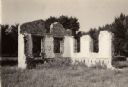
| Description: | Fort Crawford. Caption reads: "Ruins of hospital, old Fort Crawford, Prairie du Chien, Wis." |
| Date: | 1954 |
|---|---|
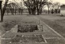
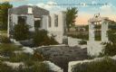
| Description: | A view of the site of the original Fort Crawford (1816-1831). |
| Date: | 1900 |
|---|---|
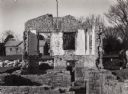
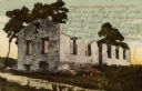
| Description: | A view of the ruins of the guardhouse used in 1883. Caption reads: "Ruins of Fort Crawford, Prairie du Chien, Wis." |

| Date: | 1910 |
|---|---|
| Description: | Fort Crawford ruins. Caption reads: "Ruins of Old Fort Crawford, Prairie-du-Chien, Wis." |
| Date: | 1925 |
|---|---|
| Description: | Fort Crawford (the second site, showing ruins of the building of 1892-?). These are the ruins of the hospital. Caption reads: "The Ruins of Old Fort Crawfo... |

| Date: | 1840 |
|---|---|
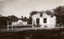
| Description: | A view of Fort Crawford (the second site and buildings of 1829-?). |

| Date: | 1829 |
|---|---|
| Description: | Fort Crawford, from a sketchbook attributed to Seth Eastman, 1808-1875. A graduate of West Point, Eastman briefly served at Fort Crawford, 1829-1839. |

| Date: | 1820 |
|---|---|
| Description: | This map displays the plan for claiming various settlement zones in the Prairie des Chiens area in 1820. It shows Fort Crawford and 87 confirmed and unconf... |

| Date: | 1882 |
|---|---|
| Description: | This map is ink on cardboard and shows the location of military forts over the course of years. Also shown are points of interest, streets, the Mississippi... |

| Date: | 01 15 1929 |
|---|---|
| Description: | Intended for tourists, this brochure, titled: "Winneshiek World’s Famous Wild Life Refuge Historic Fort Crawford and Picturesque Prairie du Chien," feature... |

| Date: | 1950 |
|---|---|
| Description: | Intended for tourists, this brochure features two maps with tourists sites along the Mississippi River. One map shows roads and populated places along the ... |

| Date: | 1856 |
|---|---|
| Description: | This map shows lot and block numbers, streets, the Mississippi River, Fort Crawford, depot ground, and a graveyard. An old fort location is outlined in red... |

| Date: | 12 05 1854 |
|---|---|
| Description: | This plat map shows landowners, the Mississippi River, the Marais de St. Friole, and an old fort. The left margin reads: "Part of the Main Village of Prair... |

| Date: | 1828 |
|---|---|
| Description: | This plat map is pen-and-ink and shows landowners, the Mississippi River, the Marais de St. Friole, Fort Crawford, the town commons, and the Village of St.... |

| Date: | 07 28 1934 |
|---|---|
| Description: | This map shows buildings and dimensions of Fort Crawford and hospital overlaid on a plat of existing lots, streets, and closed streets. |
If you didn't find the material you searched for, our Library Reference Staff can help.
Call our reference desk at 608-264-6535 or email us at: