Filter: Categories of Wisconsin Historical Images
Filter: Subject of Fortification
Filter: Type of Drawing
Filter: Categories of Wisconsin Historical Images
Filter: Subject of Fortification
Filter: Type of Drawing

| Date: | |
|---|---|
| Description: | A hand-drawn map of the state of Missouri with a separate drawing of a map showing Forts Henry and Donelson. The Missouri map includes Jefferson City and s... |
| Date: | 1817 |
|---|---|
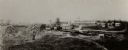
| Description: | Sketch of an elevated view of Fort Crawford (1816-1829). |

| Date: | 1829 |
|---|---|
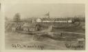
| Description: | Fort Crawford, from a sketchbook attributed to Seth Eastman, 1808-1875. A graduate of West Point, Eastman briefly served at Fort Crawford, 1829-1839. |

| Date: | 1855 |
|---|---|
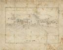
| Description: | Fox-Wisconsin portage and canal map, when the canal was not yet built. From a map in the office of the city clerk at Portage. "The old trail, the location ... |

| Date: | |
|---|---|
| Description: | Several French fur traders negotiating with native Indians at La Baye. |
| Date: | |
|---|---|
| Description: | View of Chicago from Chicago River. The homes of John Dean, J. Baptiste Beaubien, Dr. Walcott, and John Kinzie are identified by number. Fort Dearborn can ... |
| Date: | 1862 |
|---|---|
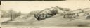
| Description: | A small amateur drawing of the camp, with surrounding terrain, occupied by the 104th Regiment, New York State Volunteers near Belle Plains, Virginia, durin... |
| Date: | 1861 |
|---|---|
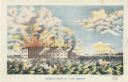
| Description: | Color lithograph of the fort in the midst of the bombardment, published by Bingham & Dodd, Hartford, Connecticut. |

| Date: | |
|---|---|
| Description: | Preliminary sketch for "Fort Pillow upon the Eve of the Evacuation by the Rebels". |
| Date: | 1852 |
|---|---|
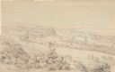
| Description: | Landscape view of Fort Snelling, Minnesota Territory from a nearby hill showing the Fort, the Mississippi river, the countryside, farm buildings and tipis.... |

| Date: | 1806 |
|---|---|
| Description: | Prehistoric Indian fortification on Hurricane Creek. |

| Date: | |
|---|---|
| Description: | A map of the prehistoric fort at Circleville with annotations by Daniel Drake. |
| Date: | |
|---|---|
| Description: | Drawing, with watercolor added, of a French fort next to a body of water with a large hill in the background. There are canoes at the water's edge. Structu... |

| Date: | |
|---|---|
| Description: | Illustration of Fort Armstrong on Rock Island, looking from opposite shoreline. There is a barge and other boats on the Mississippi River in front of the f... |

| Date: | 1615 |
|---|---|
| Description: | Illustration of the Huron Indians and French explorers attacking an Iroquois fort near present day Fenner, New York. A wooden platform was constructed to f... |
If you didn't find the material you searched for, our Library Reference Staff can help.
Call our reference desk at 608-264-6535 or email us at: