Filter: Categories of Wisconsin Historical Images
Filter: Subject of Formations (Geology)
Filter: Year of 1800-1899
Filter: Categories of Wisconsin Historical Images
Filter: Subject of Formations (Geology)
Filter: Year of 1800-1899
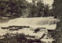
| Date: | 1880 |
|---|---|
| Description: | Willow River Falls. Text at right reads: "Published by Whitney's Gallery, St. Paul, Minn. Willow River Falls Near Hudeson, Wis." |
| Date: | 1880 |
|---|---|
| Description: | Stereograph of the Dalles and the Saint Croix River, with one man in the center foreground sitting posing on a rock and looking to the left. On the far lef... |

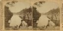
| Date: | 1878 |
|---|---|
| Description: | Kilbourn Bridge at the Wisconsin Dells, Wisconsin. A locomotive is pulling railroad cars over the bridge. |
| Date: | 1872 |
|---|---|
| Description: | An excerpt from "Picturesque America," ed. Bryant, (1872). |
| Date: | 1885 |
|---|---|
| Description: | Stereograph of Courthouse Rock. |
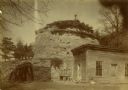
| Date: | 1836 |
|---|---|
| Description: | The shot tower at Tower Hill State Park. |
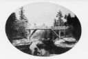
| Date: | 1866 |
|---|---|
| Description: | View of the first bridge to span the Wisconsin River, built by Schuyler Gates. It was washed away in 1866. |
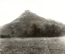
| Date: | 1896 |
|---|---|
| Description: | View of Black Hawk Bluff, site of the Battle of Wisconsin Heights in the Black Hawk War. |
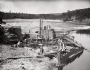
| Date: | 1895 |
|---|---|
| Description: | Elevated view of men in the midst of dam construction. |
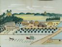
| Date: | 1875 |
|---|---|
| Description: | Seifert's watercolor is fairly large, measuring 27" wide by 21" high, and provides a detailed depiction of a nineteenth century Wisconsin farm. The small s... |
| Date: | 1890 |
|---|---|
| Description: | Old Uncle Billy Johnson home at Governor Phillip's house, about six miles north of Prairie du Sac near highway 12. Portion of house, rock formation in back... |

| Date: | 1839 |
|---|---|
| Description: | Shows locations of cities, towns, villages, post hamlets, canals, rail and stage roads. Includes table of steamboat routes and distances; vignette of "Maid... |

| Date: | 1887 |
|---|---|
| Description: | Benedict & Co. engineers. As shown by development to March 1st 1887. Inset: Map of northern Wisconsin showing location of range. Lands in red. |

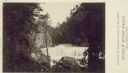
| Date: | 1890 |
|---|---|
| Description: | Big Manitou Falls on the Black River. This waterfall reportedly was called "Gitchee Monido" by the Ojibwa, which means "Falls of the Great Spirit." |

| Date: | 1869 |
|---|---|
| Description: | Increase A. Lapham in the foreground of a rock formation in Taylor's Glen, with A. Holly sitting on a rock in the background. |

| Date: | 1839 |
|---|---|
| Description: | Map of a canal route to avoid the principal rapids of the Neenah or Fox River between Lake Winnebago and Green Bay. |
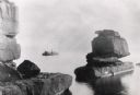
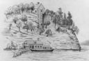
| Date: | 1898 |
|---|---|
| Description: | Rock formation, The Sphinx, on Stockton Island of the Apostle Islands. Steamer "Edna" in background on Lake Superior. |
If you didn't find the material you searched for, our Library Reference Staff can help.
Call our reference desk at 608-264-6535 or email us at: