 Filter: Categories of Wisconsin Historical Images
Filter: Subject of Formations (Geology)
Filter: Year of 1800-1899
Filter: Categories of Wisconsin Historical Images
Filter: Subject of Formations (Geology)
Filter: Year of 1800-1899

| Date: | 10 1891 |
|---|---|
| Description: | This blueprint map shows land ownership and buildings. Text below the title reads: "The La Crosse Heights include the ridge of land with the spurs projecti... |

| Date: | 1895 |
|---|---|
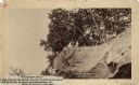
| Description: | View across water towards a house on the banks of the Mississippi River at the base of rocky bluffs. Probably located between Alma and Nelson, along Beef S... |
| Date: | 1888 |
|---|---|
| Description: | View looking up at three men and a child on top of a cliff on which are petroglyphs. Caption on photograph reads: "Pictograph Rock. Rock bearing aboriginal... |
| Date: | 1888 |
|---|---|
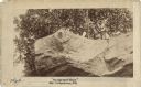
| Description: | View looking up at three men and a child on top of a cliff on which are petroglyphs. Pictograph Rock bearing aboriginal carvings, located on the south side... |

| Date: | 1899 |
|---|---|
| Description: | Elevated view of the navy yard near Wisconsin Dells. |

| Date: | 1839 |
|---|---|
| Description: | This map shows the geological makeup of the valley in red, yellow, and green, the Mississippi River, and the location of Fort Crawford. The geology on the ... |
| Date: | 1898 |
|---|---|
| Description: | Colorized postcard of an elevated view of the Devil's Doorway rock formation at Devil's Lake State Park. Devil's Lake is below in the background. Caption r... |

| Date: | 09 03 1882 |
|---|---|
| Description: | Elevated view of the steamboat Alexander Mitchell and the back of a second unidentified steamboat at a dock. Captain Dave and most of the passengers... |

| Date: | 09 04 1882 |
|---|---|
| Description: | Elevated view of the steamboat Alexander Mitchell at a dock. Captain Dave and most of the passengers on the lower level are posing standing. There i... |

| Date: | 09 04 1882 |
|---|---|
| Description: | Elevated view across water towards the steamboat Alexander Mitchell moored in the canyon along the shoreline. Captain Dave and passengers are posing... |

| Date: | 07 14 1883 |
|---|---|
| Description: | Elevated view from shoreline of the steamboat Alexander Mitchell docked at the edge of the river. Captain Dave and passengers are posing on board. B... |

| Date: | 1890 |
|---|---|
| Description: | A tall pine tree is standing just in front of Stand Rock, with the Wisconsin River in the background. |
| Date: | 04 18 1888 |
|---|---|
| Description: | Stereograph of fireplace ruins on the site of an old French fort, possibly built by Nicholas Perrot. There is an electric pole behind the fireplace and a g... |
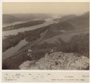
| Date: | 1880 |
|---|---|
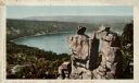
| Description: | Elevated view of two men on a rock formation in the foreground, one man sitting, and one man standing holding a flag. Below them is the Mississippi River a... |
If you didn't find the material you searched for, our Library Reference Staff can help.
Call our reference desk at 608-264-6535 or email us at: