 Filter: Categories of Wisconsin Historical Images
Filter: Subject of Formations (Geology)
Filter: Year of 1800-1899
Filter: Year of 1860-1869
Filter: Subject of water
Filter: Categories of Wisconsin Historical Images
Filter: Subject of Formations (Geology)
Filter: Year of 1800-1899
Filter: Year of 1860-1869
Filter: Subject of water
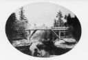
| Date: | 1866 |
|---|---|
| Description: | View of the first bridge to span the Wisconsin River, built by Schuyler Gates. It was washed away in 1866. |
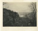
| Date: | 1866 |
|---|---|
| Description: | Cliffs along Lu-la Lake. A waterfall is in the background. Plate 15 |
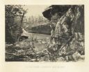
| Date: | 1866 |
|---|---|
| Description: | Elevated view of the Chattanooga Valley, with a river in the far background. A cliff face and trees are in the foreground. Plate 14 |

| Date: | 1864 |
|---|---|
| Description: | A geological map of Wisconsin that shows the locations of different rock deposits such as limestone, sandstone, shale, plutonic and the Penokee Iron Range.... |

| Date: | 1869 |
|---|---|
| Description: | This geological map shows the township grid, counties, cities and villages, rivers, lakes, railroads, and roads. Barron County is still labeled Dallas Coun... |
| Date: | 1869 |
|---|---|
| Description: | Two girls in long dresses on a rock formation. The river and far shoreline is in the background. Text on left reads: "A Visit to Devil's Lake, Sauk County,... |

| Date: | 1867 |
|---|---|
| Description: | This 1867 manuscript map by Increase Lapham shows the topography and geology of the Blue Mounds region in the Town of Brigham in Iowa County and the towns ... |

| Date: | 1866 |
|---|---|
| Description: | This manuscript map by Increase Lapham shows the Dells of the Wisconsin River, from Stand Rock and Witches Gulch at the north to a point approximately one ... |
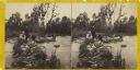
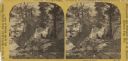
| Date: | 1860 |
|---|---|
| Description: | Two men and two women visit sit on a small, rocky island or natural bridge near water. Plants and trees are on shoreline behind them. |
If you didn't find the material you searched for, our Library Reference Staff can help.
Call our reference desk at 608-264-6535 or email us at: