 Filter: Categories of Wisconsin Historical Images
Filter: Subject of Formations (Geology)
Filter: Year of 1800-1899
Filter: Subject of superior, lake
Filter: Categories of Wisconsin Historical Images
Filter: Subject of Formations (Geology)
Filter: Year of 1800-1899
Filter: Subject of superior, lake

| Date: | 1821 |
|---|---|
| Description: | Engraving of the Pictured Rocks shoreline viewed from Lake Superior. |

| Date: | 1852 |
|---|---|
| Description: | Illustration of the Ojibwa, the Sacs, and Foxes battling from canoes on the water. |

| Date: | 1854 |
|---|---|
| Description: | Drawing of the Porcupine Mountains on Lake Superior. A deer is standing in the lake drinking water. A man is on the rock ledge above the shoreline and is a... |
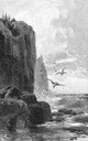
| Date: | 04 1892 |
|---|---|
| Description: | Drawing of the north shore of Lake Superior with cliffs and seagulls. |

| Date: | 1887 |
|---|---|
| Description: | Benedict & Co. engineers. As shown by development to March 1st 1887. Inset: Map of northern Wisconsin showing location of range. Lands in red. |
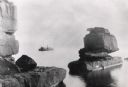
| Date: | 1898 |
|---|---|
| Description: | Rock formation, The Sphinx, on Stockton Island of the Apostle Islands. Steamer "Edna" in background on Lake Superior. |
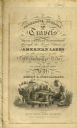
| Date: | 1820 |
|---|---|
| Description: | Narrative Journal of Travels from Detroit Northwest through the Great chain of American Lakes to the sources of the Mississippi River in the year 1820. Ill... |

| Date: | 1855 |
|---|---|
| Description: | This map shows counties, cities, rivers, canals, lakes, railroads, common roads, county towns, townships, villages, and post offices. The map includes part... |
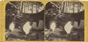
| Date: | 1885 |
|---|---|
| Description: | Stereograph of a sailboat in Excursion Cave, on Hemlock Island of the Apostle Islands. A man can be seen sitting in the boat. |

| Date: | 1864 |
|---|---|
| Description: | A geological map of Wisconsin that shows the locations of different rock deposits such as limestone, sandstone, shale, plutonic and the Penokee Iron Range.... |

| Date: | 1882 |
|---|---|
| Description: | A geological map of northern Wisconsin showing the locations of different soil types in the state such as sandy soil, sandy loam, prairie loam, clayey loam... |

| Date: | 1874 |
|---|---|
| Description: | This map of Wisconsin shows cities, counties, railroads already completed and railroads projected, and geological makeup of the land such as lakes. |

| Date: | 1869 |
|---|---|
| Description: | This geological map shows the township grid, counties, cities and villages, rivers, lakes, railroads, and roads. Barron County is still labeled Dallas Coun... |

| Date: | 1847 |
|---|---|
| Description: | This map identifies surveyed areas of the Upper Peninsula and shows lakes, rivers, and islands in portions of Wisconsin, Minnesota, Michigan, and upper Can... |
If you didn't find the material you searched for, our Library Reference Staff can help.
Call our reference desk at 608-264-6535 or email us at: