 Filter: Categories of Wisconsin Historical Images
Filter: Subject of Formations (Geology)
Filter: Year of 1800-1899
Filter: Subject of land
Filter: Categories of Wisconsin Historical Images
Filter: Subject of Formations (Geology)
Filter: Year of 1800-1899
Filter: Subject of land
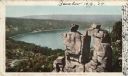
| Date: | 1898 |
|---|---|
| Description: | Colorized postcard view of the Devil's Doorway rock formation overlooking Devil's Lake. Caption reads: "Devil's Doorway, Devil's Lake, Wis." |
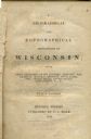
| Date: | 1844 |
|---|---|
| Description: | Title page of Increase Lapham's A Geographical and Topographical Description of Wisconsin published by P.C. Hale of Milwaukee, Wisconsin. |

| Date: | 09 04 1885 |
|---|---|
| Description: | Exterior and interior bill of fare from The Chequamegon, with views on the back of rock formations, waterfalls, a spot illustration of a train going over a... |
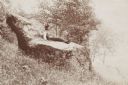
| Date: | 1898 |
|---|---|
| Description: | Man and woman seated on an overgrown hillside. The woman has ferns on her lap and is holding an umbrella. Inscribed on reverse of original mount: "B.D.L. a... |
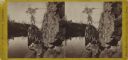
| Date: | 1885 |
|---|---|
| Description: | Elevated view over water towards an elderly man using a long pole to fish from a steep rock ledge on the opposite shoreline. |
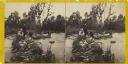
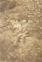
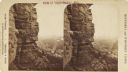
| Date: | 1860 |
|---|---|
| Description: | Two men and two women visit sit on a small, rocky island or natural bridge near water. Plants and trees are on shoreline behind them. |
| Date: | 1870 |
|---|---|
| Description: | Stereograph of the dalles of the St. Croix river, on the Wisconsin-Minnesota border. Along the shoreline on the right, a woman in a long dress is posing on... |

| Date: | 1890 |
|---|---|
| Description: | Group of tourists and crew members on the bow deck of the DELL QUEEN, an excursion boat that operated on the Wisconsin River at Wisconsin Dells. |
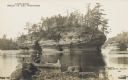
| Date: | 1888 |
|---|---|
| Description: | Photographic postcard view from shoreline of the rock formation in the Dells of the Wisconsin River. A man is paddling a canoe in the foreground. Printed o... |
| Date: | 1895 |
|---|---|
| Description: | Young man sitting on a large rock called the “Devil's Chair” in Rattlesnake Hollow. |

| Date: | 1895 |
|---|---|
| Description: | Elevated view from bluffs, looking north-east toward Lake City, Minnesota and Lake Pepin of the Mississippi River. |
| Date: | 1890 |
|---|---|
| Description: | Stereograph view from the bluffs looking down over a town. A man is standing on the edge of the side of the formation, about halfway up, above treeline, an... |

| Date: | 1892 |
|---|---|
| Description: | Elevated view upriver towards a railroad bridge crossing the river. Rocks are in the foreground in the middle of the river. Identified as the bridge across... |

| Date: | 1892 |
|---|---|
| Description: | Elevated view upriver towards a bridge and dam. Two people are walking among the rocks on the lower right. Identified as the railroad bridge across the Bla... |

| Date: | 09 01 1856 |
|---|---|
| Description: | This map is pen-and-ink and shows farm lots, other lots of land sectioned by acres, bluffs, and a coulee. Also included are notations in pencil and blue in... |

| Date: | 1886 |
|---|---|
| Description: | This map shows north and south ore veins, landownership, railroads, rivers, and township grid in parts of Ashland County, Wis. and Ontonagon County, Mich. ... |

| Date: | 1847 |
|---|---|
| Description: | This map identifies surveyed areas of the Upper Peninsula and shows lakes, rivers, and islands in portions of Wisconsin, Minnesota, Michigan, and upper Can... |

| Date: | 1858 |
|---|---|
| Description: | This map shows the depth of the West Channel and the different types of minerals that make up the floor bed. The steamboat range station is labeled. A note... |
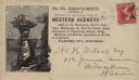
| Date: | 1891 |
|---|---|
| Description: | H.H. Bennett advertising envelope addressed to William H. Metcalf of Milwaukee. The envelope bears an engraved image of people standing on top of Stand Roc... |

| Date: | 1883 |
|---|---|
| Description: | This map shows the geology of areas in Montana, the Dakotas, Nebraska, Wyoming, Idaho, Colorado, Kansas, Arizona, New Mexico, and Utah. Map also shows lake... |
If you didn't find the material you searched for, our Library Reference Staff can help.
Call our reference desk at 608-264-6535 or email us at: