 Filter: Categories of Wisconsin Historical Images
Filter: Subject of Formations (Geology)
Filter: Year of 1800-1899
Filter: County of Dane
Filter: Categories of Wisconsin Historical Images
Filter: Subject of Formations (Geology)
Filter: Year of 1800-1899
Filter: County of Dane
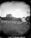
| Date: | 1876 |
|---|---|
| Description: | View of a farmstead with fences, haystacks and a wooden building. A man is in the background on top of McCord Rock, also called Devil's Chimney, Preacher'... |

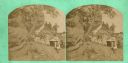
| Date: | 1876 |
|---|---|
| Description: | View of a farmstead with fences, haystacks and a wooden outbuilding. Two men are posing on top of McCord Rock, one of them saluting with his hat. Another ... |
| Date: | 1874 |
|---|---|
| Description: | "Curiosities in Springdale, Wisconsin." A view of Nellie Springen, perhaps with her family, at a rocky outcropping enjoying coffee. |

| Date: | 1867 |
|---|---|
| Description: | This 1867 manuscript map by Increase Lapham shows the topography and geology of the Blue Mounds region in the Town of Brigham in Iowa County and the towns ... |
If you didn't find the material you searched for, our Library Reference Staff can help.
Call our reference desk at 608-264-6535 or email us at: