| Date: | 1839 |
|---|---|
| Description: | Map of a canal route to avoid the principal rapids of the Neenah or Fox River between Lake Winnebago and Green Bay. |

| Date: | 1864 |
|---|---|
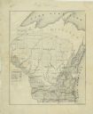
| Description: | A geological map of Wisconsin that shows the locations of different rock deposits such as limestone, sandstone, shale, plutonic and the Penokee Iron Range.... |

| Date: | 1882 |
|---|---|
| Description: | A geological map of northern Wisconsin showing the locations of different soil types in the state such as sandy soil, sandy loam, prairie loam, clayey loam... |

| Date: | 09 01 1856 |
|---|---|
| Description: | This map is pen-and-ink and shows farm lots, other lots of land sectioned by acres, bluffs, and a coulee. Also included are notations in pencil and blue in... |
If you didn't find the material you searched for, our Library Reference Staff can help.
Call our reference desk at 608-264-6535 or email us at: