Filter: Categories of Wisconsin Historical Images
Filter: Subject of Formations (Geology)
Filter: Subject of water
Filter: County of Dane
Filter: Categories of Wisconsin Historical Images
Filter: Subject of Formations (Geology)
Filter: Subject of water
Filter: County of Dane
| Date: | 07 23 1931 |
|---|---|
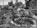
| Description: | Girl sitting in Arthur G. Clemens rock garden made with stones from every county in southern Wisconsin. Also includes pond, at 706 W. Lakeside Street. |
| Date: | 07 23 1931 |
|---|---|
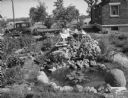
| Description: | Girl sitting in Arthur G. Clemens rock garden made with stones from every county in southern Wisconsin. Also includes pond, 706 W. Lakeside Street. |
| Date: | 11 20 1926 |
|---|---|
| Description: | View from Observatory Hill of the new Men's Lakeshore dormitories at the University of Wisconsin-Madison, showing Chamberlin Rock in the foreground. The do... |
| Date: | 1926 |
|---|---|
| Description: | View of Adams, Tripp and Van Hise Halls. All are residence halls on the University of Wisconsin campus with Picnic Point and Lake Mendota in the backgroun... |

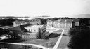
| Date: | 1945 |
|---|---|
| Description: | Aerial view of Bascom Hill, Bascom Hall, Wisconsin Historical Society on the University of Wisconsin Madison campus with Lake Mendota on the right. |

| Date: | 1876 |
|---|---|
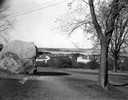
| Description: | View of a farmstead with fences, haystacks and a wooden outbuilding. Two men are posing on top of McCord Rock, one of them saluting with his hat. Another ... |
| Date: | |
|---|---|
| Description: | Second Point in Maple Bluff looking toward Woodward's Grove. |
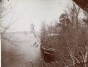
| Date: | |
|---|---|
| Description: | Lake Mendota near Maple Bluff with an old stone boat landing. |

| Date: | 1900 |
|---|---|
| Description: | Hydrographic map of Lake Mendota and it's adjacent topography. Prepared from surveys made by civil engineering students, University of Wisconsin, classes 1... |
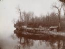
| Date: | |
|---|---|
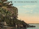
| Description: | View of Profile Rock at Farwell Point on Lake Mendota. Caption reads: "Profile Rock, Lake Mendota, Madison, Wis." |

| Date: | |
|---|---|
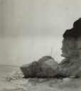
| Description: | A view of Profile Rock at Farwell Point on Lake Mendota. |
| Date: | |
|---|---|
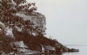
| Description: | View of the shoreline of Lake Mendota and Profile Rock at Farwell Point. |

| Date: | |
|---|---|
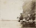
| Description: | Several men and boys sail in a canoe near a foliage covered rock outcropping. The boat is decorated with two flags, an American flag and one reading "JULIA... |
| Date: | |
|---|---|
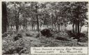
| Description: | Photographic postcard of picnic grounds at a spring in Blue Mounds State Park. The spring is running out of a brick catch basin on the right. A woman weari... |

| Date: | 1957 |
|---|---|
| Description: | Color postcard of Dream River, North Cave, opened in 1957, in the Cave of the Mounds. |

| Date: | 1947 |
|---|---|
| Description: | Colorized postcard of a girl throwing a penny into the Brownie's Wishing Well in the Cave of the Mounds. Caption reads: "Brownie's Wishing Well." |

| Date: | 1867 |
|---|---|
| Description: | This 1867 manuscript map by Increase Lapham shows the topography and geology of the Blue Mounds region in the Town of Brigham in Iowa County and the towns ... |

| Date: | 05 16 1908 |
|---|---|
| Description: | View across water of the summer cottages on Maple Bluff. |
If you didn't find the material you searched for, our Library Reference Staff can help.
Call our reference desk at 608-264-6535 or email us at: