Filter: Categories of Wisconsin Historical Images
Filter: Subject of Formations (Geology)
Filter: Subject of ice
Filter: Categories of Wisconsin Historical Images
Filter: Subject of Formations (Geology)
Filter: Subject of ice
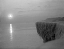
| Date: | 1912 |
|---|---|
| Description: | Sunrise over a frozen cliff on Lake Michigan. |
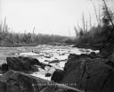
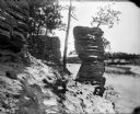
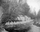
| Date: | 1900 |
|---|---|
| Description: | Big Falls, looking down the Flambeau River. There are large boulders in the foreground and patches of ice in the river. Caption at bottom reads: "Big Falls... |
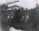
| Date: | 1960 |
|---|---|
| Description: | Excavation for bridge column footings for the Mirror Lake Bridge. |
| Date: | |
|---|---|
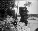
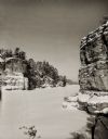
| Description: | Elevated view of the Jaws rock formation in the Wisconsin Dells. |
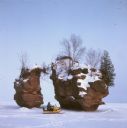
| Date: | |
|---|---|
| Description: | View of the Jaws rock formation. The Wisconsin River is frozen, and snow covers the trees and ground. |
| Date: | 1910 |
|---|---|
| Description: | A winter view of Chimney Rock at the Dells. There is snow on the ground and ice on the river. |
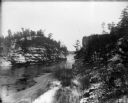
| Date: | 1910 |
|---|---|
| Description: | View from bank of the Wisconsin River of the Jaws of the Dells in winter. Snow is on the ground and ice lines the shoreline. |
| Date: | 1909 |
|---|---|
| Description: | Elevated view of a woman holding a walking stick and wearing a hat and fur coat with a fur stole sitting on a ledge of ice at Skillet Falls. Bare trees fra... |
| Date: | 1909 |
|---|---|
| Description: | A well-dressed woman with a walking stick stands on ice at the partially frozen Skillet Falls. Bare trees frame the scene. There are patches of snow and tr... |

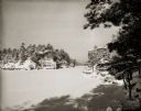
| Date: | |
|---|---|
| Description: | Stereograph of winter scene in Rood's Glen covered with ice and snow. Text at left: "Wanderings Among the Wonders and Beauties of Wisconsin Scenery." |
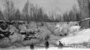
| Date: | 1934 |
|---|---|
| Description: | Three men standing on frozen Lake Superior in front of ice covered shoreline. |
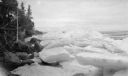
| Date: | 04 1922 |
|---|---|
| Description: | Large slabs and piles of ice line the rocky shoreline of Lake Michigan, possibly at Europe Bay. |
| Date: | 1920 |
|---|---|
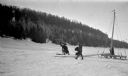
| Description: | Three men work with an iceboat just offshore near Cottage Row Road. The sail and boom lie on the ice. There are boathouses and three windmills along the ... |

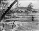
| Date: | 1900 |
|---|---|
| Description: | View from ice-covered river of Dripping Springs along shoreline in winter. |
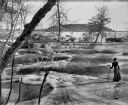
| Date: | |
|---|---|
| Description: | View of a creek with ice-covered and tree-lined banks. Identified as Perry Creek. |

| Date: | |
|---|---|
| Description: | View across ice towards a large skating party posing for a group portrait. In the background along the shoreline is an exposed cliff with bushes and trees ... |
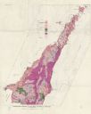
| Date: | 1961 |
|---|---|
| Description: | This map shows bays, lakes, and roads. Relief is shown by contours; depths are shown by isolines. Lake Michigan and Lake Winnebago are labeled. An explana... |
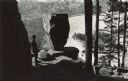
| Date: | |
|---|---|
| Description: | Elevated view of a man standing on a rock looking over a frozen Devil's Lake in front of a Balanced Rock. Original caption: "There are some startling rock ... |
| Date: | |
|---|---|
| Description: | View across frozen bay towards a person riding a snowmobile in front of a split rock formation on Chequamegon Bay. |
If you didn't find the material you searched for, our Library Reference Staff can help.
Call our reference desk at 608-264-6535 or email us at: