 Filter: Categories of Wisconsin Historical Images
Filter: Subject of Formations (Geology)
Filter: Subject of bays
Filter: Categories of Wisconsin Historical Images
Filter: Subject of Formations (Geology)
Filter: Subject of bays

| Date: | 1968 |
|---|---|
| Description: | A topographic map of east central Wisconsin, that covers an area stretching from Green Bay on the east to Edgar and Vesper on the west, Wausau on the north... |

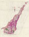
| Date: | 1915 |
|---|---|
| Description: | This map shows the extent of Wisconsin and pre-Wisconsin drift. The bottom left of the map includes a map categorizing the colors used into geologic period... |
| Date: | 1961 |
|---|---|
| Description: | This map shows bays, lakes, and roads. Relief is shown by contours; depths are shown by isolines. Lake Michigan and Lake Winnebago are labeled. An explana... |
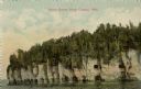
| Date: | |
|---|---|
| Description: | View across water towards the bluffs at the northern end of Door County. |

| Date: | 1909 |
|---|---|
| Description: | View across water towards the steep shoreline and lighthouse at Eagle Harbor. |

| Date: | |
|---|---|
| Description: | View from water towards Eagle Cliff (Bluff) in Peninsula State Park Caption reads: "Eagle Cliff, Ephraim, Wis." |
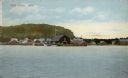
| Date: | 1911 |
|---|---|
| Description: | Hand-colored view of Fish Creek from the bay. A boathouse and main dock are in the center. A bluff is in the background. Caption reads: "Fish Creek, Wis." |
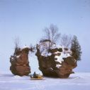
| Date: | |
|---|---|
| Description: | View across frozen bay towards a person riding a snowmobile in front of a split rock formation on Chequamegon Bay. |

| Date: | |
|---|---|
| Description: | A man and women are posing on a rock formation and looking out over the big bay near Stand Rock. Boats are on the river in the distance. |

| Date: | |
|---|---|
| Description: | An unidentified young man is standing next to an unidentified young women sitting on a rock over looking Palisades and Big Bay. |
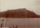
| Date: | 1902 |
|---|---|
| Description: | View of a tree-lined mountain across a body of water. Caption reads: "Trempealeau Mountain from across the bay." |
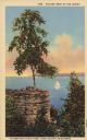
| Date: | 1935 |
|---|---|
| Description: | Text on front reads: "Picture Rock at the Ledges, Potowatomi State Park, Door County, Wisconsin." A sailboat on Sturgeon Bay seen between a rock formation ... |
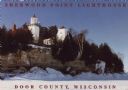
| Date: | 1963 |
|---|---|
| Description: | Text on front reads: "Sherwood Point Lighthouse, Door County, Wisconsin." On reverse: "Sherwood Point Lighthouse is near Potawatomi State Park, north of St... |
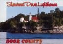
| Date: | 1963 |
|---|---|
| Description: | Text on front reads: "Sherwood Point Lighthouse, Door County." On reverse: "Built in 1883, the Sherwood Point Lighthouse marks the entrance into Sturgeon B... |
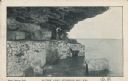
| Date: | 01 17 1907 |
|---|---|
| Description: | Text on front reads: "Lovers' Leap, Sturgeon Bay, Wis." Two men are posing while sitting on a block of stone under an overhang on Cabot's Point. The shorel... |
If you didn't find the material you searched for, our Library Reference Staff can help.
Call our reference desk at 608-264-6535 or email us at:
