 Filter: Categories of Wisconsin Historical Images
Filter: Subject of Formations (Geology)
Filter: County of Ashland
Filter: Type of Map or Atlas
Filter: Categories of Wisconsin Historical Images
Filter: Subject of Formations (Geology)
Filter: County of Ashland
Filter: Type of Map or Atlas
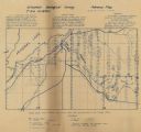
| Date: | 1920 |
|---|---|
| Description: | Shows geology, test pits, shafts, houses, and the Mellen Lumber Co. Ry. in Marengo township, Ashland County, Wisconsin. "This is a preliminary map issued i... |

| Date: | 1886 |
|---|---|
| Description: | This map shows north and south ore veins, landownership, railroads, rivers, and township grid in parts of Ashland County, Wis. and Ontonagon County, Mich. ... |
If you didn't find the material you searched for, our Library Reference Staff can help.
Call our reference desk at 608-264-6535 or email us at: