 Filter: Categories of Wisconsin Historical Images
Filter: Subject of Formations (Geology)
Filter: Community of Madison
Filter: Year of 1900-1999
Filter: Categories of Wisconsin Historical Images
Filter: Subject of Formations (Geology)
Filter: Community of Madison
Filter: Year of 1900-1999
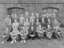
| Date: | 06 03 1938 |
|---|---|
| Description: | Group portrait men, and one woman, of University of Wisconsin Geology Club next to Science Hall. |
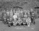
| Date: | 05 24 1937 |
|---|---|
| Description: | Group portrait of men in the Geology Club, taken in front of the north side of Science Hall, University of Wisconsin-Madison. |
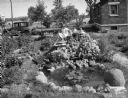
| Date: | 07 23 1931 |
|---|---|
| Description: | Girl sitting in Arthur G. Clemens rock garden made with stones from every county in southern Wisconsin. Also includes pond, at 706 W. Lakeside Street. |
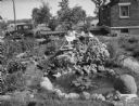
| Date: | 07 23 1931 |
|---|---|
| Description: | Girl sitting in Arthur G. Clemens rock garden made with stones from every county in southern Wisconsin. Also includes pond, 706 W. Lakeside Street. |
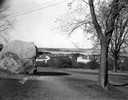
| Date: | 11 20 1926 |
|---|---|
| Description: | View from Observatory Hill of the new Men's Lakeshore dormitories at the University of Wisconsin-Madison, showing Chamberlin Rock in the foreground. The do... |
| Date: | 1909 |
|---|---|
| Description: | A billboard displays events at the foot of Bascom Hill from the bottom east side on the University of Wisconsin-Madison campus. Bascom Hall with dome (form... |
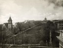
| Date: | 1900 |
|---|---|
| Description: | The view of Bascom Hill and upper campus of the University of Wisconsin Madison seen from the roof of the Wisconsin Historical Society. |
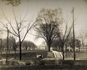
| Date: | 1926 |
|---|---|
| Description: | View of Adams, Tripp and Van Hise Halls. All are residence halls on the University of Wisconsin campus with Picnic Point and Lake Mendota in the backgroun... |

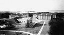
| Date: | 1945 |
|---|---|
| Description: | Aerial view of Bascom Hill, Bascom Hall, Wisconsin Historical Society on the University of Wisconsin Madison campus with Lake Mendota on the right. |

| Date: | 1900 |
|---|---|
| Description: | Hydrographic map of Lake Mendota and it's adjacent topography. Prepared from surveys made by civil engineering students, University of Wisconsin, classes 1... |
| Date: | 06 08 1908 |
|---|---|
| Description: | Pen-and-ink on paper. Shows vicinity of Washburn Observatory and University Hall at the University of Wisconsin-Madison. Relief shown by contours and spot ... |

| Date: | 06 21 1959 |
|---|---|
| Description: | Nancy Muckenhirn is shown with Devil's Lake rocks that the Black Hawk Council of Girl Scouts will be taking to Colorado Springs for the Senior Girl Scout R... |

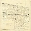
| Date: | 05 16 1908 |
|---|---|
| Description: | View across water of the summer cottages on Maple Bluff. |

| Date: | 05 16 1908 |
|---|---|
| Description: | A view from the west of Maple Bluff. Part of the roof of a cottage can be seen above the bluff. |

| Date: | 05 16 1908 |
|---|---|
| Description: | View across water of Governor's Island. There is a far shoreline in the background on the left. |

| Date: | 1902 |
|---|---|
| Description: | This map is watercolor and pen on paper and relief shown by contours. The map reads: "Contour interval 10 feet." Shown on the map are geological features a... |
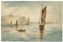
| Date: | 1905 |
|---|---|
| Description: | Watercolor painting of boats and sailboats on Lake Mendota, looking towards Maple Bluff, perhaps from Governor's Island or Rocky Roost. |
If you didn't find the material you searched for, our Library Reference Staff can help.
Call our reference desk at 608-264-6535 or email us at: