Filter: Categories of Wisconsin Historical Images
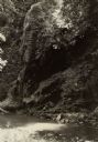
Filter: Subject of Formations (Geology)
Filter: Creator Name of Unknown
Filter: Categories of Wisconsin Historical Images
Filter: Subject of Formations (Geology)
Filter: Creator Name of Unknown
| Date: | |
|---|---|
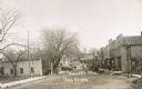
| Description: | View down Main Street, with a hill at the end of the street. Pedestrians are walking on the sidewalks, and horse-drawn vehicles are along the unpaved stree... |
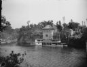
| Date: | 1922 |
|---|---|
| Description: | View from shoreline across river towards the steamboat "Winnebago" docked at the Dells Boat Landing on the opposite shoreline. |
| Date: | 1929 |
|---|---|
| Description: | Ceremonial performers in traditional Indian costume pose near a steamboat. |
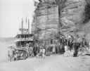
| Date: | 1920 |
|---|---|
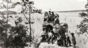
| Description: | A group of Indians, probably Ho-Chunk, in traditional costume, posing on and around Demon's Anvil. |
| Date: | 1890 |
|---|---|
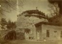
| Description: | Old Uncle Billy Johnson home at Governor Phillip's house, about six miles north of Prairie du Sac near highway 12. Portion of house, rock formation in back... |
| Date: | 1905 |
|---|---|
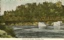
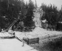
| Description: | Petenwell Bridge. Caption reads: "Pete-eu-nell Bridge, Necedah, Wis." |
| Date: | 1918 |
|---|---|
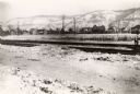
| Description: | View of the Burlington Railroad tracks south of the city, near Campion College. Dwellings are across a field, and snow-covered bluffs are in the background... |
| Date: | 1960 |
|---|---|
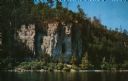
| Description: | View across water towards the 180-foot high Eagle Bluff. The bluff received its name from the eagles which formerly nested there. |
| Date: | 1960 |
|---|---|
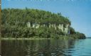
| Description: | View across water towards the 180-foot high Eagle Bluff. The bluff received its name from the eagles which formerly nested there. |
| Date: | 1910 |
|---|---|
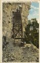
| Description: | View of the steps leading to Eagle Cave on Eagle Bluff. The bluff received its name from the eagles which formerly nested there. Caption reads: "Scene at E... |

| Date: | 1890 |
|---|---|
| Description: | Big Manitou Falls on the Black River. This waterfall reportedly was called "Gitchee Monido" by the Ojibwa, which means "Falls of the Great Spirit." |
| Date: | 1940 |
|---|---|
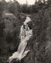
| Description: | Big Manitou Falls on the Black River. It is referred to as the "lower falls" in the park. This 165-foot waterfall is recognized as the highest in the state... |
| Date: | 1914 |
|---|---|
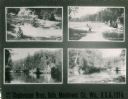
| Description: | Various views of places in Oslo. Text at bottom reads: "Stephenson Bros., Oslo, Manitowoc Co., Wis., U.S.A., 1914." |
| Date: | |
|---|---|
| Description: | The stairs and dock at the lighthouse on Rock Island. |

| Date: | 1839 |
|---|---|
| Description: | Map of a canal route to avoid the principal rapids of the Neenah or Fox River between Lake Winnebago and Green Bay. |
| Date: | 1898 |
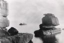
|---|---|
| Description: | Rock formation, The Sphinx, on Stockton Island of the Apostle Islands. Steamer "Edna" in background on Lake Superior. |
| Date: | |
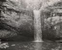
|---|---|
| Description: | Foster Falls, near Highlander Folk School. This site was often used for picknicking. |
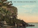
| Date: | |
|---|---|
| Description: | View of Profile Rock at Farwell Point on Lake Mendota. Caption reads: "Profile Rock, Lake Mendota, Madison, Wis." |
If you didn't find the material you searched for, our Library Reference Staff can help.
Call our reference desk at 608-264-6535 or email us at: