Filter: Categories of Wisconsin Historical Images
Filter: Subject of Formations (Geology)
Filter: Creator Name of Unknown
Filter: Subject of water
Filter: Categories of Wisconsin Historical Images
Filter: Subject of Formations (Geology)
Filter: Creator Name of Unknown
Filter: Subject of water
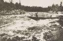
| Date: | 1900 |
|---|---|
| Description: | Lumbermen in a bateau descending rapids in an unidentified northern or north-central Wisconsin river. |

| Date: | 1895 |
|---|---|
| Description: | Elevated view from bluffs, looking north-east toward Lake City, Minnesota and Lake Pepin of the Mississippi River. |

| Date: | 04 09 1936 |
|---|---|
| Description: | The Buffalo Head, a 'native' stone sculpture by the Mississippi River at the junction of Flint Ledge and Indian trails in Wyalusing State Park. The verso... |

| Date: | 1900 |
|---|---|
| Description: | Photographic postcard view up the Wisconsin River near the foot of Grandfather Falls, which falls 90 feet in 1 1/2 miles. Caption reads: "Near the foot of ... |
| Date: | 1910 |
|---|---|
| Description: | Elevated view of the Chippewa River. Caption reads: "Chippewa River, Cornell, Wis." |

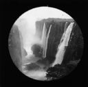
| Date: | 1910 |
|---|---|
| Description: | View of Zambezi River, South Africa, from a boat tour. The railroad bridge is in the far background. |
| Date: | 1910 |
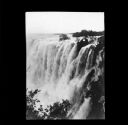
|---|---|
| Description: | Elevated view of Victoria Falls, South Africa, looking down at the Zambezi River. |

| Date: | 1910 |
|---|---|
| Description: | A view of the Zambezi Bridge from Palm Grove, South Africa. |

| Date: | 1910 |
|---|---|
| Description: | View along shoreline towards Echo Rock on Mirror Lake. Caption reads: "Echo Rock, Mirror Lake, Delton, Wis." |
| Date: | 1910 |
|---|---|
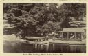
| Description: | View across water towards the North Side Landing. There is a covered tour boat at the edge of the lake and passengers on board. At the shoreline is a cabin... |
| Date: | 1910 |
|---|---|
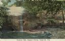
| Description: | Color enhanced postcard across water towards a man standing near a cliff face and observing a waterfall. Located in Governor Dodge State Park on STH 23 nor... |

| Date: | 1910 |
|---|---|
| Description: | Black and white photographic postcard view of a waterfall on the Little Niagara River. A footbridge extends over the waterfall. |

| Date: | 1909 |
|---|---|
| Description: | A black and white photographic postcard view looking up a river toward a waterfall. Caption reads: "The Cascades." |
| Date: | 1910 |
|---|---|
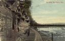
| Description: | Colored photographic postcard view of the dells below the dam on the Chippewa river. There is a boardwalk at the base of the cliff leading to the dam. Capt... |
| Date: | |
|---|---|
| Description: | View looking down at Skillet Creek Falls, which are surrounded by rocks, trees and foliage. Skillet Creek, located on private land, flows to Pewit's Nest, ... |

| Date: | |
|---|---|
| Description: | View across water towards Governor's Island and its exposed cliff at the shoreline with trees and plants growing on top. Governor’s Island, formerly part o... |

| Date: | 08 1948 |
|---|---|
| Description: | Sigurd F. Olson standing on cliff overlooking Robinson Lake in Quetico Provincial Park. Another person is sitting on a boulder next to where he stands. |

| Date: | 1920 |
|---|---|
| Description: | This blueprint map covers the boundary area between Lake Superior and the Lac Vieux Desert. The map reads: "Land lines, streams, lakes, railroads, cities a... |

| Date: | |
|---|---|
| Description: | View across lake towards steep bluffs. Trees are growing along the shoreline and on the top of the bluffs. At the base of the cliffs in the center is a sca... |
If you didn't find the material you searched for, our Library Reference Staff can help.
Call our reference desk at 608-264-6535 or email us at: